988489670.ppt
- Количество слайдов: 13

Branch of MSU to him Lomanosova in Dushanbe city Jamoliddin
One of the unique features of our home planet is the water that covers approximately 71% of its surface. It is life-sustaining—nourishing every plant, animal, and human cell on Earth—and plays a major role in the complex processes of Earth’s climate. NASA’s Earth-observing satellites improve our understanding of our global water systecm. They monitor water-related processes such as sea-level change to help determine the effects on coastal areas and implications for global climate. 2
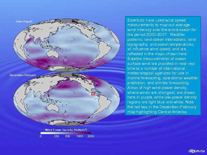
Scientists have used wind speed measurements to map out average wind intensity over the entire ocean for the period 2000– 2007. Weather patterns, land-ocean interactions, land topography, and ocean temperatures, all influence wind speed, and are reflected in the maps shown here. Satellite measurements of ocean surface wind are provided in near real time to a number of international meteorological agencies for use in marine forecasting, operational weather prediction, and climate forecasting. Areas of high wind-power density, where winds are strongest, are shown here in purple, while low-power density regions are light blue and white. Note the red box in the December–February map highlighting Central America. June–August December–February Wind Power Density (Watts/m 2) 0 250 500 1000 2000 3
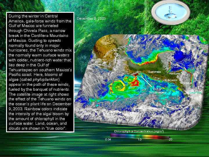
During the winter in Central America, gale-force winds from the Gulf of Mexico are funneled through Chivela Pass, a narrow break in the Cordillera Mountains of Mexico. Gusting to speeds normally found only in major hurricanes, the Tehuano winds mix the normally warm surface waters with colder, nutrient-rich water that lies deep in the Gulf of Tehuantepec on southern Mexico’s Pacific coast. Here, blooms of algae (called phytoplankton) appear in the path of these winds, fueled by the banquet of nutrients. The satellite image at right shows the effect of the Tehuano winds on the ocean’s plant life on December 9, 2003. Rainbow colors indicate the intensity of the algal bloom by the amount of chlorophyll in the surface water. Land, ocean, and clouds are shown in “true color”. December 9, 2003 Gulf of Mexico Guatemala Honduras El Salvador Nicaragua Gulf of Tehuantepec Costa Rica Pacific Ocean Chlorophyll-a Concentration (mg/m 3) 0. 04 1. 0 20 4
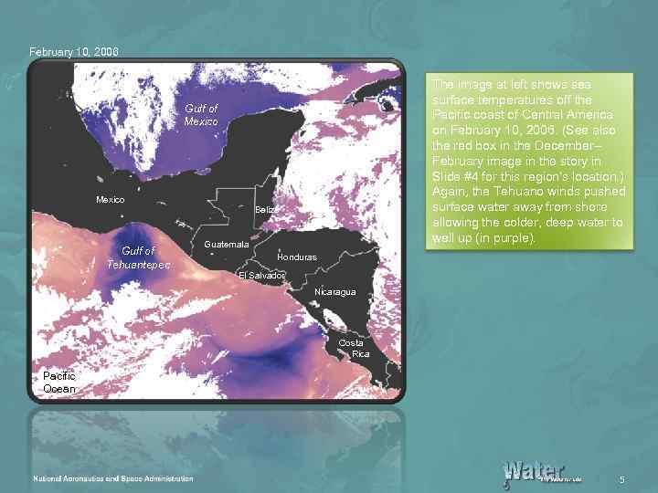
February 10, 2006 The image at left shows sea surface temperatures off the Pacific coast of Central America on February 10, 2006. (See also the red box in the December– February image in the story in Slide #4 for this region’s location. ) Again, the Tehuano winds pushed surface water away from shore allowing the colder, deep water to well up (in purple). Gulf of Mexico Gulf of Tehuantepec Belize Guatemala Honduras El Salvador Nicaragua Costa Rica Pacific Ocean 5
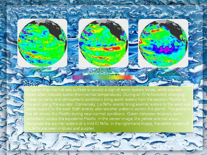
Calm Pacific Ocean: May 21, 2006 La Niña: February 4, 2008 Mild El Niño: November 20, 2006 Sea Surface Height (millimeters) -180 -100 -60 0 60 100 180 A higher-than-normal sea surface is usually a sign of warm waters below, while low sea levels often indicate cooler-than-normal temperatures. During an El Niño event, changing ocean currents and atmospheric conditions bring warm waters from the western Pacific to the east along the equator. Conversely, La Niña events bring warmer waters to the west and cooler waters to the east. Both events alter weather patterns across the planet. The globe on the left shows the Pacific during near-normal conditions. Green indicates relatively calm conditions across the equatorial Pacific. In the center image, the yellow and red areas designate the warmer waters of a mild El Niño. In the right-hand image, the colder waters of La Niña are seen in blues and purples. 6
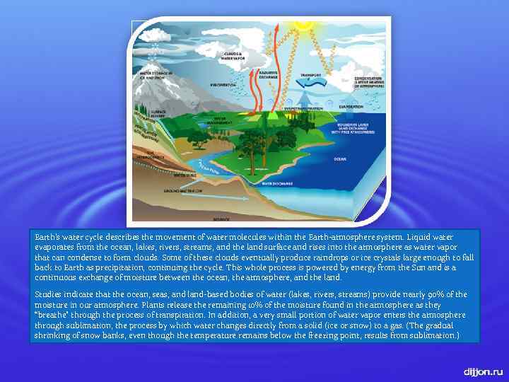
Earth’s water cycle describes the movement of water molecules within the Earth-atmosphere system. Liquid water evaporates from the ocean, lakes, rivers, streams, and the land surface and rises into the atmosphere as water vapor that can condense to form clouds. Some of these clouds eventually produce raindrops or ice crystals large enough to fall back to Earth as precipitation, continuing the cycle. This whole process is powered by energy from the Sun and is a continuous exchange of moisture between the ocean, the atmosphere, and the land. Studies indicate that the ocean, seas, and land-based bodies of water (lakes, rivers, streams) provide nearly 90% of the moisture in our atmosphere. Plants release the remaining 10% of the moisture found in the atmosphere as they “breathe” through the process of transpiration. In addition, a very small portion of water vapor enters the atmosphere through sublimation, the process by which water changes directly from a solid (ice or snow) to a gas. (The gradual shrinking of snow banks, even though the temperature remains below the freezing point, results from sublimation. ) 7
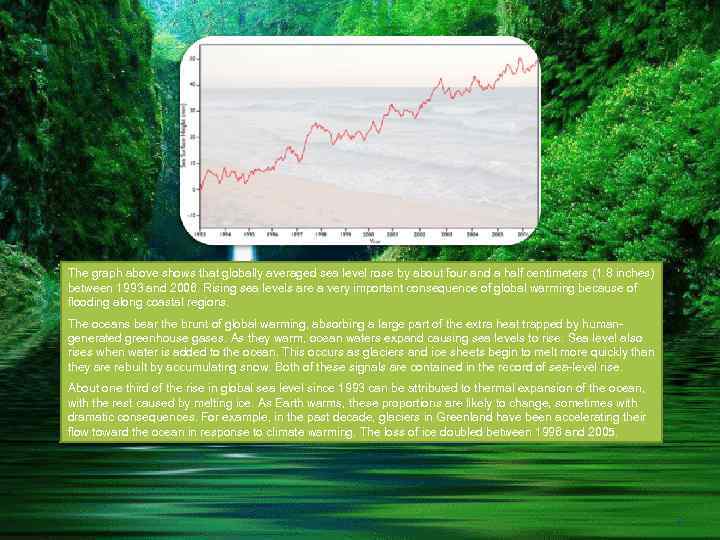
The graph above shows that globally averaged sea level rose by about four and a half centimeters (1. 8 inches) between 1993 and 2006. Rising sea levels are a very important consequence of global warming because of flooding along coastal regions. The oceans bear the brunt of global warming, absorbing a large part of the extra heat trapped by humangenerated greenhouse gases. As they warm, ocean waters expand causing sea levels to rise. Sea level also rises when water is added to the ocean. This occurs as glaciers and ice sheets begin to melt more quickly than they are rebuilt by accumulating snow. Both of these signals are contained in the record of sea-level rise. About one third of the rise in global sea level since 1993 can be attributed to thermal expansion of the ocean, with the rest caused by melting ice. As Earth warms, these proportions are likely to change, sometimes with dramatic consequences. For example, in the past decade, glaciers in Greenland have been accelerating their flow toward the ocean in response to climate warming. The loss of ice doubled between 1996 and 2005. 8
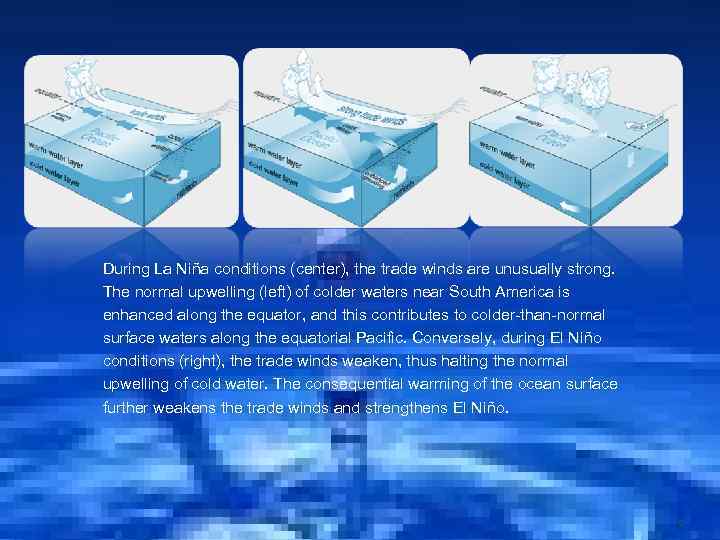
During La Niña conditions (center), the trade winds are unusually strong. The normal upwelling (left) of colder waters near South America is enhanced along the equator, and this contributes to colder-than-normal surface waters along the equatorial Pacific. Conversely, during El Niño conditions (right), the trade winds weaken, thus halting the normal upwelling of cold water. The consequential warming of the ocean surface further weakens the trade winds and strengthens El Niño. 9
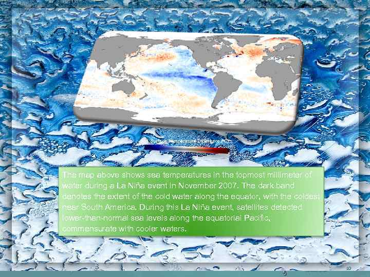
Sea Surface Temperature Difference (°C) -5 0 5 The map above shows sea temperatures in the topmost millimeter of water during a La Niña event in November 2007. The dark band denotes the extent of the cold water along the equator, with the coldest near South America. During this La Niña event, satellites detected lower-than-normal sea levels along the equatorial Pacific, commensurate with cooler waters. 10
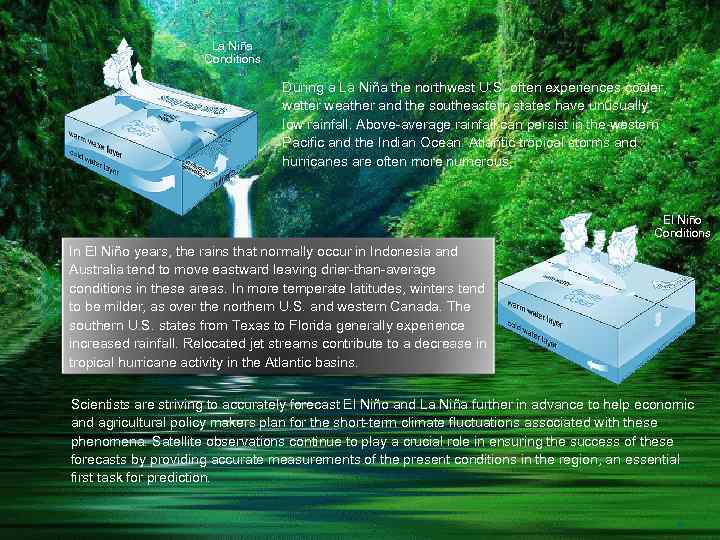
La Niña Conditions During a La Niña the northwest U. S. often experiences cooler, wetter weather and the southeastern states have unusually low rainfall. Above-average rainfall can persist in the western Pacific and the Indian Ocean. Atlantic tropical storms and hurricanes are often more numerous. El Niño Conditions In El Niño years, the rains that normally occur in Indonesia and Australia tend to move eastward leaving drier-than-average conditions in these areas. In more temperate latitudes, winters tend to be milder, as over the northern U. S. and western Canada. The southern U. S. states from Texas to Florida generally experience increased rainfall. Relocated jet streams contribute to a decrease in tropical hurricane activity in the Atlantic basins. Scientists are striving to accurately forecast El Niño and La Niña further in advance to help economic and agricultural policy makers plan for the short-term climate fluctuations associated with these phenomena. Satellite observations continue to play a crucial role in ensuring the success of these forecasts by providing accurate measurements of the present conditions in the region, an essential first task for prediction. 11

Thank you For JAMOLIDDIN attention! 12

13
988489670.ppt