20184f0ae1e1a09c77aceaf74306d196.ppt
- Количество слайдов: 27
Aviation Weather Office FAA and In Situ Observations Presented to: Japanese Meteorological Agency By: Tammy Farrar Weather Policy and Requirements Group Date: March 24, 2009 Federal Aviation Administration
FAA and In Situ Observations • In Situ Utilization Today – Operations • ITWS – Research • AWRP • Next Gen Implications – Overview – Major Programs With In Situ Implications • NNEW • RWI • WTIC • Questions? FAA and In Situ Observations March 24, 2009 Federal Aviation Administration 2 2
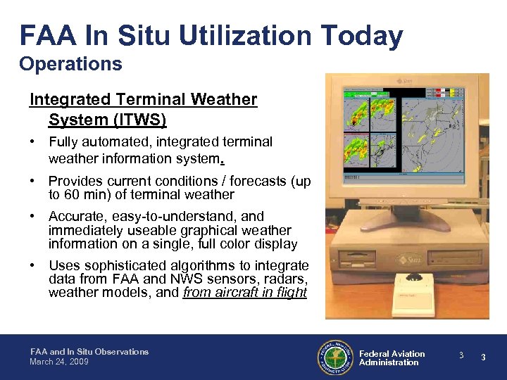
FAA In Situ Utilization Today Operations Integrated Terminal Weather System (ITWS) • Fully automated, integrated terminal weather information system. • Provides current conditions / forecasts (up to 60 min) of terminal weather • Accurate, easy-to-understand, and immediately useable graphical weather information on a single, full color display • Uses sophisticated algorithms to integrate data from FAA and NWS sensors, radars, weather models, and from aircraft in flight FAA and In Situ Observations March 24, 2009 Federal Aviation Administration 3 3
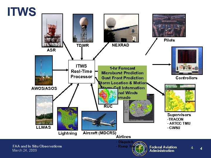
ITWS Pilots TDWR NEXRAD ASR ITWS Real-Time Processor AWOS/ASOS 1 -hr Forecast Microburst Prediction Gust Front Prediction Storm Location & Motion Storm Cell Information Terminal Winds Tornado Controllers RUC Supervisors -TRACON - ARTCC TMU - CWSU LLWAS Lightning FAA and In Situ Observations March 24, 2009 Aircraft (MDCRS) Airlines - Dispatch - Ramp Tower Federal Aviation Administration 4 4
FAA In Situ Utilization Today Operations Integrated Terminal Weather System (ITWS) • Users: – Air Traffic personnel in the Air Traffic Control Tower (ATCT) and Terminal Radar Control (TRACON) facility – Traffic Management and Center Weather Service Unit personnel in the Air Route Traffic Control Center (ARTCC) – Air Traffic Control Systems Command Center (ATCSCC), airport authorities, airline dispatch offices and other Users (i. e. airlines) • Authorized FAA & non-FAA users have internet access to ITWS products • ITWS products will be made compatible with Next. Gen requirements FAA and In Situ Observations March 24, 2009 Federal Aviation Administration 5 5
FAA In Situ Utilization Today Research Aviation Weather Research Program (AWRP) • Plans and conducts research, development of new weather capabilities and technologies to meet current and future aviation needs. • Turbulence Research Team improving detection of en route turbulence • Developed Eddy Dissipation Rate (EDR) algorithms • Accelerometer-based algorithm in UAL a/c; improved winds-based algorithm on DAL a/c, in process of implementing on SWA a/c • EDR data displayed on Aviation Digital Data Service (ADDS) • FY 09/10: Yearlong demonstration with DAL to investigate the benefits of EDR to NAS capacity/safety and airline operations • QC’d EDR data displayed on Earth Systems Research Laboratory (ESRL) Global Systems Division (GSD) AMDAR display • EDR integrated into the Graphical Turbulence Guidance (GTG-2) product, soon to be operational FAA and In Situ Observations March 24, 2009 Federal Aviation Administration 6 6
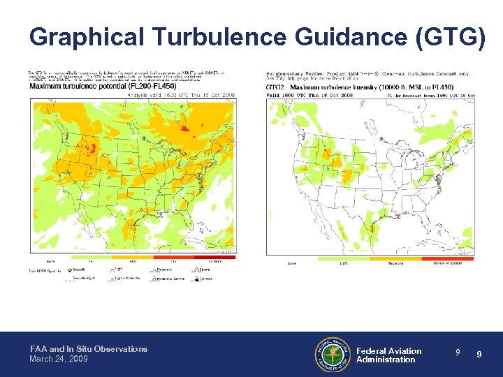
Graphical Turbulence Guidance (GTG) • Based on RUC NWP model – GTG 1 • Upper-level CAT (>FL 200) • Operational on ADDS since 3/2003 • http: //adds. aviationweather. noaa. gov – GTG 2 • Clear-air sources 10, 000 ft MSL-FL 450 • On Experimental ADDS since 11/2004 • Will replace GTG 1 on operational ADDS in 2009 – Uses a combination of turbulence diagnostics, merged and weighted according to current performance (pireps, EDR) • Current work areas – Probabilistic forecasts of moderate-or-greater (MOG) and severe-or-greater (SOG) turbulence – Optimal use of insitu reports – Assimilation of turbulence-related observations FAA and In Situ Observations March 24, 2009 Federal Aviation Administration 7 7
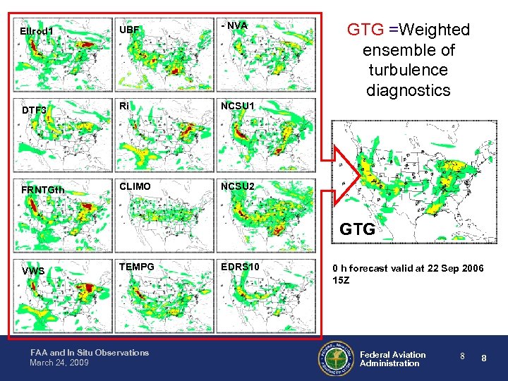
Ellrod 1 UBF - NVA DTF 3 Ri NCSU 1 FRNTGth CLIMO GTG =Weighted ensemble of turbulence diagnostics NCSU 2 GTG VWS TEMPG FAA and In Situ Observations March 24, 2009 EDRS 10 0 h forecast valid at 22 Sep 2006 15 Z Federal Aviation Administration 8 8
Graphical Turbulence Guidance (GTG) FAA and In Situ Observations March 24, 2009 Federal Aviation Administration 9 9
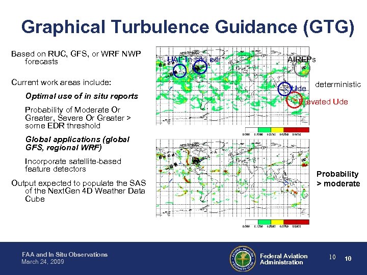
Graphical Turbulence Guidance (GTG) Based on RUC, GFS, or WRF NWP forecasts Current work areas include: Optimal use of in situ reports Probability of Moderate Or Greater, Severe Or Greater > some EDR threshold UAL In situ edr AIREPs Ude deterministic Elevated Ude Global applications (global GFS, regional WRF) Incorporate satellite-based feature detectors Probability > moderate Output expected to populate the SAS of the Next. Gen 4 D Weather Data Cube FAA and In Situ Observations March 24, 2009 Federal Aviation Administration 10 10
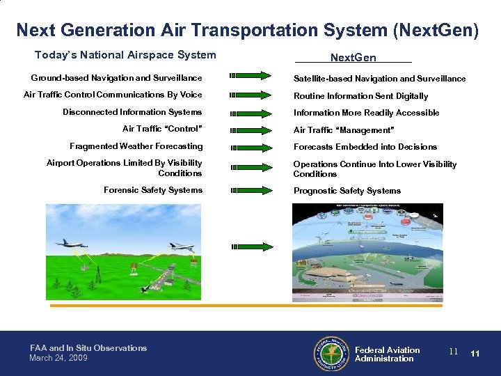
Next Generation Air Transportation System (Next. Gen) Today’s National Airspace System Ground-based Navigation and Surveillance Air Traffic Control Communications By Voice Disconnected Information Systems Air Traffic “Control” Fragmented Weather Forecasting Airport Operations Limited By Visibility Conditions Forensic Safety Systems FAA and In Situ Observations March 24, 2009 Next. Gen Satellite-based Navigation and Surveillance Routine Information Sent Digitally Information More Readily Accessible Air Traffic “Management” Forecasts Embedded into Decisions Operations Continue Into Lower Visibility Conditions Prognostic Safety Systems Federal Aviation Administration 11 11
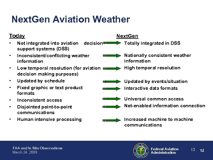
Next. Gen Aviation Weather Today Next. Gen • • Totally integrated in DSS • • Nationally consistent weather information High temporal resolution • • Updated by events/situation Interactive data formats • • Universal common access Net-enabled information connection • Increased machine to machine communications • • Not integrated into aviation decisionsupport systems (DSS) Inconsistent/conflicting weather information Low temporal resolution (for aviation decision making purposes) Updated by schedule Fixed graphic or text product formats Inconsistent access Disjointed point-to-point communications Human intensive processing FAA and In Situ Observations March 24, 2009 Federal Aviation Administration 12 12
Next. Gen Network Enabled Weather (NNEW) • The 4 -D Weather Cube will provide common, universal access to aviation weather data. • Improved weather data (observations & forecasts) available from the 4 -D Weather Data Cube will improve traffic management capability and reduce delays. • Provide Single Authoritative Source (SAS) of weather information for all users. • Provide access to weather information indexed by aircraft and weather type. • Reduce the need for human interpretation of data by direct machineto-machine access & integration in decision support tools. FAA and In Situ Observations March 24, 2009 Federal Aviation Administration 13 13
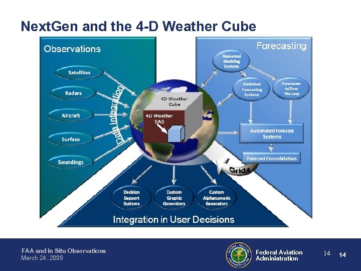
Next. Gen and the 4 -D Weather Cube FAA and In Situ Observations March 24, 2009 Federal Aviation Administration 14 14
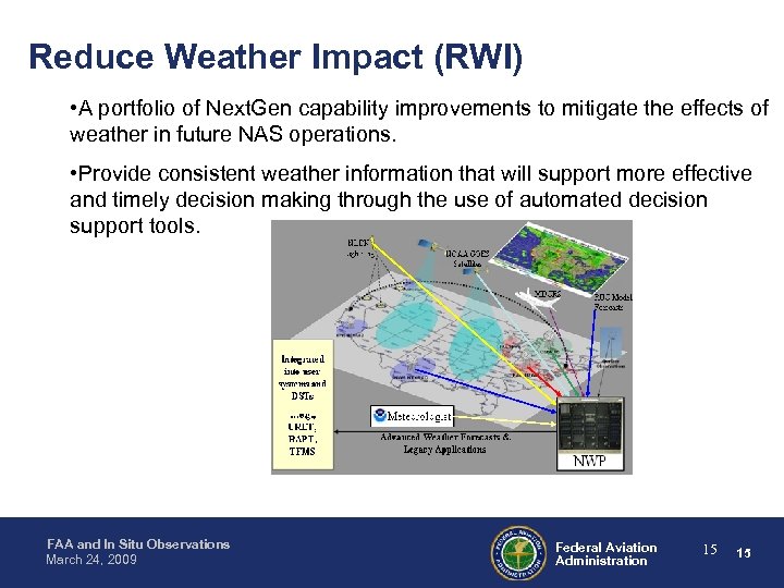
Reduce Weather Impact (RWI) • A portfolio of Next. Gen capability improvements to mitigate the effects of weather in future NAS operations. • Provide consistent weather information that will support more effective and timely decision making through the use of automated decision support tools. NLDN Lightnin g NOAA GOES Satellites MDCRS Integrate d into user systems and DSTs …e. g. , URET, RAPT, TFMS FAA and In Situ Observations March 24, 2009 RUC Model Forecasts Meteorologist Advanced Weather Forecasts & Legacy Applications NWP Federal Aviation Administration 15 15
Reduce Weather Impact Two major elements: Weather Forecast Improvements • Integrate weather information tailored for Decision Support Tools (DSTs) and systems into Next. Gen operations • Implement improved forecasts by transitioning advanced capabilities from aviation weather research • Develop metrics to evaluate the effectiveness of weather improvements in the NAS • Develop probabilistic forecasts which can be used for traffic flow management • Determine the most effective solution for a processor architecture to support these capabilities • Propose recommendations for transitioning FAA legacy weather systems into Next. Gen. FAA and In Situ Observations March 24, 2009 Federal Aviation Administration 16 16
Reduce Weather Impact Two major elements: Weather Observation Improvements • Optimize the weather sensor network to eliminate redundancy and inconsistencies among sensor types, configurations, and ground infrastructure reducing cost and improving performance • Determine the right sensor mix among ground-based, satellite, and airborne atmospheric sensor networks • Improve the resolution of the weather sensor network • Effort being worked jointly with government, industry, and academic agencies FAA and In Situ Observations March 24, 2009 Federal Aviation Administration 17 17
Weather Technology in the Cockpit (WTIC) • A portfolio of related research and development (R&D) activities to ensure the adoption of cockpit, ground, and communication technologies, practices, and procedures that will: – Provide pilots with shared and consistent weather information to enhance common situational awareness – Provide airborne tools to exploit the common weather picture – Utilize the “aircraft as a node” functions to autonomously exchange weather information with surrounding aircraft and ground systems – Facilitate integration of weather information into cockpit Next. Gen capabilities (e. g. Trajectory Based Operations) FAA and In Situ Observations March 24, 2009 Federal Aviation Administration 18 18
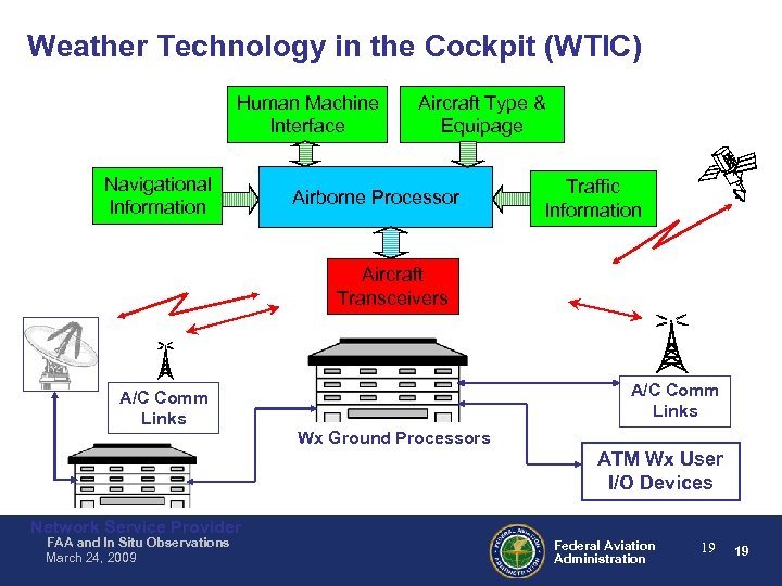
Weather Technology in the Cockpit (WTIC) Human Machine Interface Navigational Information Aircraft Type & Equipage Airborne Processor Traffic Information Aircraft Transceivers A/C Comm Links Wx Ground Processors ATM Wx User I/O Devices Network Service Provider FAA and In Situ Observations March 24, 2009 Federal Aviation Administration 19 19

QUESTIONS? FAA and In Situ Observations March 24, 2009 Federal Aviation Administration 20 20
Back-up Slides FAA and In Situ Observations March 24, 2009 Federal Aviation Administration 21 21
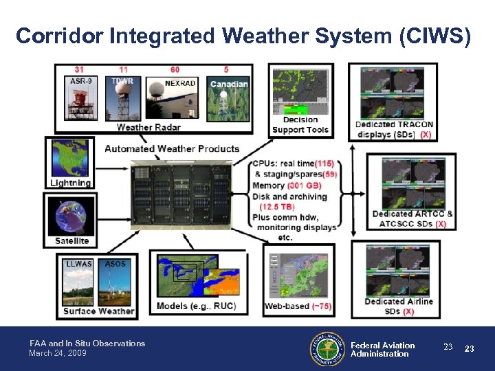
Corridor Integrated Weather System (CIWS) • Background – CIWS is an automated weather processing system that ingests weather sensor and model data to generate a suite of convective weather forecast (0 – 2 Hr) products for the northeast corridor. • CIWS does not incorporate airborne sensor data • Integration of CIWS products with Traffic Flow Management Decision Support Tools • CIWS functionality will be component in Next. Gen Weather Processor – CIWS products are currently disseminated to 15 FAA facilities (ATCSCC, ARTCCs, TRACONs), airlines operations centers, and several R&D organizations. – CIWS was developed, operated and maintained by MIT Lincoln Laboratory FAA and In Situ Observations March 24, 2009 Federal Aviation Administration 22 22
Corridor Integrated Weather System (CIWS) FAA and In Situ Observations March 24, 2009 Federal Aviation Administration 23 23
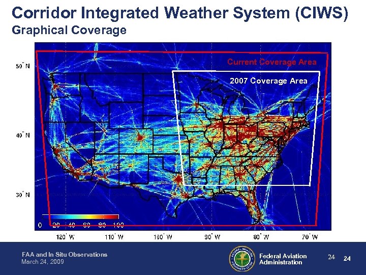
Corridor Integrated Weather System (CIWS) Graphical Coverage Current Coverage Area 2007 Coverage Area FAA and In Situ Observations March 24, 2009 Federal Aviation Administration 24 24
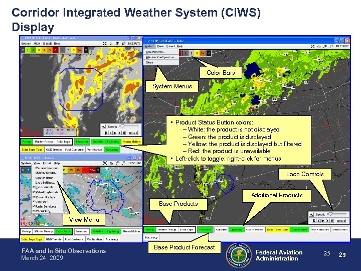
Corridor Integrated Weather System (CIWS) Display Color Bars System Menus • Product Status Button colors: – White: the product is not displayed – Green: the product is displayed – Yellow: the product is displayed but filtered – Red: the product is unavailable • Left-click to toggle; right-click for menus Loop Controls Additional Products Base Products View Menu FAA and In Situ Observations March 24, 2009 Base Product Forecast Federal Aviation Administration 25 25
ITWS-How does it fit into the NAS? • ITWS is integrated into the FAA’s Strategic Management Plan • ITWS helps fill the performance gap identified in the FAA’s Greater Capacity goal: – Objective 1: Increase airport capacity to meet projected demand – Strategy 1: Improve technologies to make air traffic flow more efficiently during periods of adverse weather • ITWS provides significant economic benefits in airline operations efficiencies and passenger time savings – Estimated benefits to cost ratios as high as 19. 8: 1 FAA and In Situ Observations March 24, 2009 Federal Aviation Administration 26 26
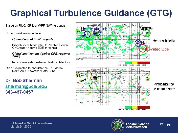
Graphical Turbulence Guidance (GTG) Based on RUC, GFS, or WRF NWP forecasts UAL In situ edr AIREPs Current work areas include: Optimal use of in situ reports Probability of Moderate Or Greater, Severe Or Greater > some EDR threshold Ude deterministic Elevated Ude Global applications (global GFS, regional WRF) Incorporate satellite-based feature detectors Output expected to populate the SAS of the Next. Gen 4 D Weather Data Cube Dr. Bob Sharman sharman@ucar. edu 303 -497 -8457 FAA and In Situ Observations March 24, 2009 Probability > moderate Federal Aviation Administration 27 27
20184f0ae1e1a09c77aceaf74306d196.ppt