08aef4aea123bc2afc0fc2cda01f4168.ppt
- Количество слайдов: 72
 AVIATION MATHEMATICS
 www. faa. gov Training and Testing Training Resources and Guides Pilot Training Download: • Pilot’s Handbook of Aeronautical Knowledge • Airplane Flying Handbook
 www. faa. gov
 www. faa. gov
 Requirements for Private Pilot Certificate 14 CFR Part 61 • Minimum age 17 • Read, speak, write, understand English • Current third-class medical certificate • Score at least 70% on the Knowledge Test • Total of 40 hrs of instruction & solo flight time • Pass an oral exam and flight check
 FAA Knowledge Test: Private Pilot – Airplane • Minimum age 15 • 60 multiple choice questions • Must be completed in 2. 5 hrs • A score of 70% required to pass
 www. faa. gov Training and Testing Under Testing, select: Sample Airman Knowledge Test Questions Under Pilot, select Private Download: Airman Knowledge Test Question Bank
 Airman Knowledge Test Question Bank • Contains over 300 questions for Private Pilot • Does NOT provide answers • Each sample question has a code number, corresponding to a Learning Statement Code
 Learning Statement Reference Guide • Contains over 500 Learning Statements • First 100 involve: Ø “Calculate” (some quantity) Ø “Interpret” (a graph, chart, etc) • The rest are mostly “Recall”
 Mathematical Concepts • • • Rounding off Converting units Estimating Interpolation Subscripted variables Square Roots Ratio and Proportion Formulas (e. g. , for Weight and Balance) Variation (direct and inverse) Vectors and Trig (e. g. , for crosswind components)
 #62 PLT 012 An aircraft departs an airport in the central standard time zone at 0845 CST for a 2 -hr flight to an airport located in the mountain standard time zone. The landing should be at what coordinated universal time? A) 1345 Z B) 1445 Z C) 1645 Z Learning Statement PLT 012: Calculate aircraft performance: time/speed/distance/course/fuel/wind
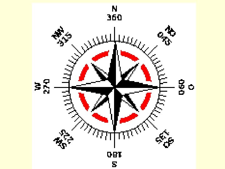
 UTC = Coordinated Universal Time • The time at the 0° line of longitude which passes through Greenwich England Often called Zulu time
 Prime Meridian
 Time zones change every 15° of longitude 360° / 24 = 15° The Earth revolves at 15° per hour
 To Convert to UTC: EST CST MST PST Add 5 hours Add 6 hours Add 7 hours Add 8 hours (For daylight saving time, subtract 1 hour from the calculated times).
 An aircraft departs an airport in the central standard time zone at 0845 CST for a 2 -hr flight to an airport located in the mountain standard time zone. The landing should be at what coordinated universal time? A) 1345 Z B) 1445 Z C) 1645 Z
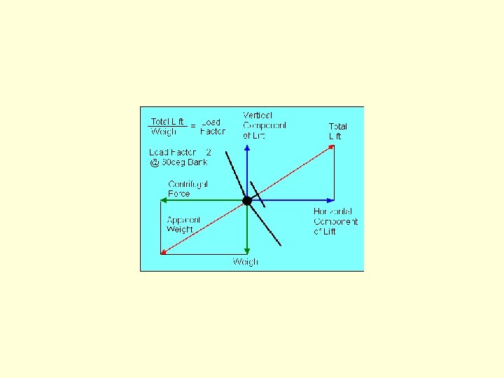
 #1 PLT 309 If an airplane weighs 2, 300 pounds, what approximate weight would the airplane structure be required to support during a 60° banked turn while maintaining altitude? A) 2, 300 pounds. B) 3, 400 pounds. C) 4, 600 pounds. Learning Statement PLT 309: Recall load factor - angle of bank
 In straight and level, unaccelerated flight LIFT = WEIGHT and THRUST = DRAG
 Level Turn
 Straight and level flight Wings support a load equal to the sum of the weight of the airplane plus its contents
 Load Factor = Total Lift /Weight Load factor = 1 G in straight and level flight
 Load Factor = Total Lift /Weight Ratio of the load supported by wings to the actual weight of the aircraft and its contents.
 Turns Increase the Load Factor Wings must support a load equal to the weight of the airplane plus the load imposed by centrifugal force.
 Load Factor vs. Bank Angle
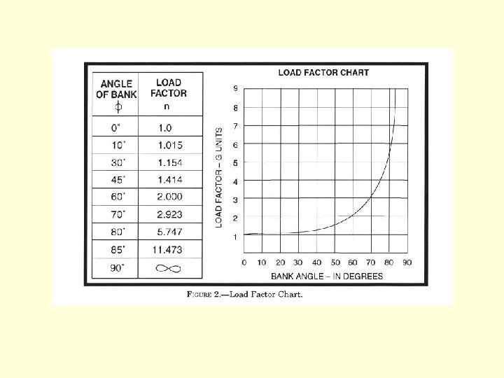
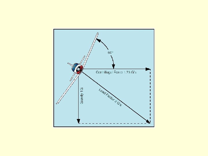
 #1 PLT 309 If an airplane weighs 2, 300 pounds, what approximate weight would the airplane structure be required to support during a 60° banked turn while maintaining altitude? A) 2, 300 pounds. B) 3, 400 pounds. C) 4, 600 pounds.
 If an airplane weighs 3, 300 pounds, what approximate weight would the airplane structure be required to support during a 30° banked turn while maintaining altitude? A) 1, 200 pounds. B) 3, 100 pounds. C) 3, 960 pounds.
 If an airplane weighs 4, 500 pounds, what approximate weight would the airplane structure be required to support during a 45° banked turn while maintaining altitude? A) 4, 500 pounds. B) 6, 750 pounds. C) 7, 200 pounds.
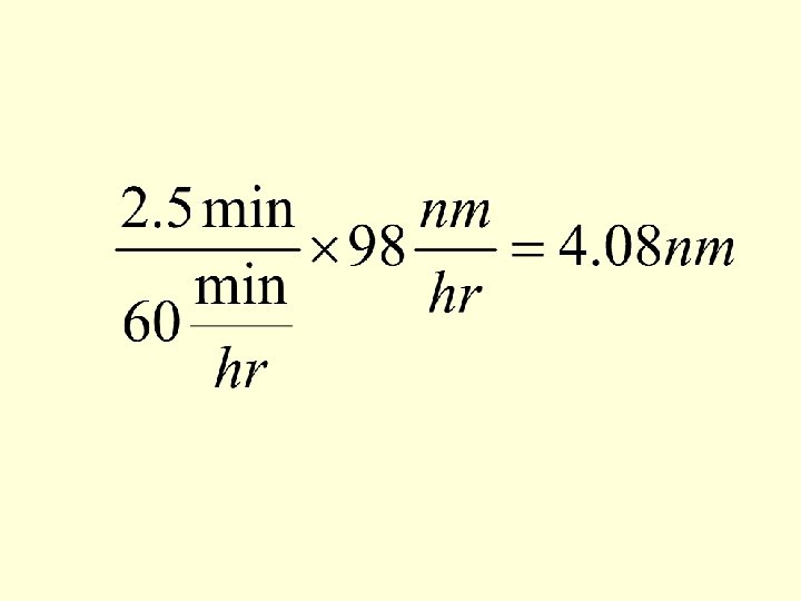
 How far will an aircraft travel in 2 -1/2 minutes with a groundspeed of 98 knots? A) 2. 45 NM B) 3. 35 NM C) 4. 08 NM
 Nautical Mile Historical Definition 1 nm = length of 1 minute of arc of latitude along any meridian
 10, 000 m from Equator to North Pole along the Meridian of Paris
 Historical Definition of Meter • 10, 000 m from Equator to North Pole along the Meridian of Paris • 40, 000 m = Circumference of Earth = 40, 000 km
 Historical Definition of Nautical Mile • 360 degrees * 60 minutes/degree = 21, 600 minutes in a circle of longitude • 1 nautical mile = the length of 1 minute of arc on a meridian • 1 nm = 40, 000 km /21, 600=1. 85185 km
 Modern definition of Nautical Mile 1 nm = 1852. 0 m 1 nm ≈ 1. 15 statute miles
 1 KNOT = 1 nautical mile / hr
 How far will an aircraft travel in 2 -1/2 minutes with a groundspeed of 98 knots? A) 2. 45 NM B) 3. 35 NM C) 4. 08 NM
 When operating below 18, 000 feet MSL in VFR cruising flight more than 3, 000 feet above the surface and on a magnetic course of 0° through 179°, any odd thousand-foot MSL altitude plus 500 feet (3, 500, 5, 500, etc. ) is appropriate. On a course of 180° through 359°, even thousands plus 500 feet (4, 500, 6, 500, etc. ) is appropriate. (B 09) 14 CFR § 91. 159
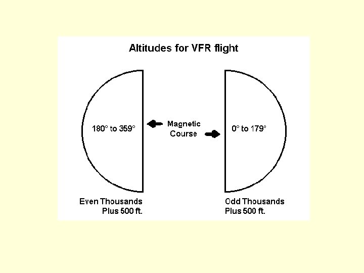
 Which VFR cruising altitude is appropriate when flying above 3, 000 feet AGL on a magnetic course of 185°? A) 4, 000 feet B) 4, 500 feet C) 5, 000 feet
 #256 PLT 467 Which cruising altitude is appropriate for a VFR flight on a magnetic course of 135°? A) Even thousandths. B) Even thousandths plus 500 feet. C) Odd thousandths plus 500 feet.
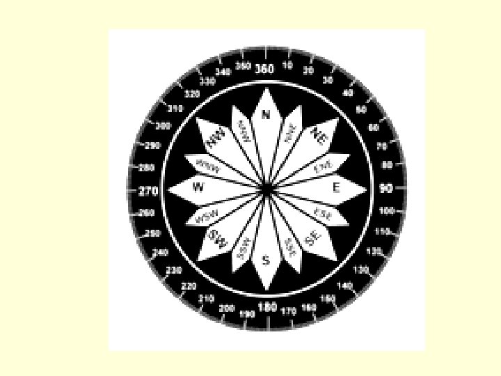
 Reciprocal Headings If Initial Heading < 180° Reciprocal Heading = Initial Heading + 200° – 20° If Initial Heading > 180° Reciprocal Heading = Initial Heading – 200° + 20°
 Runway 9/27
 Runway Numbers • Runway numbers are in reference to magnetic north • Determined from the approach direction
 Runway Numbers • Start with magnetic heading of runway • Round to nearest 10° • Drop the last digit
 Runways • KLGA 13/31 and 4/22 • KDCA 1/19, 15/33, and 4/22 • KIAD 1 L/19 R, 1 R/19 L, and 12/30 • KCLT 18 R/36 L, 18 L/36 R, and 5/23 • KLEX 4/22 and 8/26
 #201 PLT 141 The numbers 8 and 26 on the approach ends of the runway indicate that the runway is orientated approximately A) 008° and 026° true. B) 080° and 260° true. C) 080° and 260° magnetic.
") KLEX (Blue Grass Airport)
KLEX (Blue Grass Airport)
 Runway 8/26 RUNWAY 8 Runway heading: RUNWAY 26 085 magnetic, 081 true 265 magnetic, 261 true Runway 4/22 RUNWAY 4 Runway heading: RUNWAY 22 046 magnetic, 042 true 226 magnetic, 222 true
 226 magnetic 265 magnetic") KLEX (Blue Grass Airport) 226 magnetic 265 magnetic
KLEX (Blue Grass Airport) 226 magnetic 265 magnetic
 Standard Weights ITEM WEIGHT General Aviation Crew and Passenger Gasoline 170 lbs each Oil 7. 5 lbs/U. S. gallon Water 8. 35 lbs/U. S. gallon 6 lbs/U. S. gallon
") An aircraft is loaded 110 lbs over maximum certificated gross weight. If fuel (gasoline) is drained to bring the aircraft weight within limits, how much fuel should be drained? A) 15. 7 gallons B) 16. 2 gallons C) 18. 4 gallons
An aircraft is loaded 110 lbs over maximum certificated gross weight. If fuel (gasoline) is drained to bring the aircraft weight within limits, how much fuel should be drained? A) 15. 7 gallons B) 16. 2 gallons C) 18. 4 gallons
 Dynamic Hydroplaning • Airplane tires ride on a thin sheet of water • Results in loss of braking and directional control • VHP = Minimum dynamic hydroplaning spd • Once hydroplaning starts, it can continue at speeds well below the minimum initial hydroplaning speed
 • Tire pressure usually ranges from 80") Hydroplaning Speed • VHP = 9√(tire pressure) • Tire pressure usually ranges from 80 psi to 200 psi • √(tire pressure) ranges from 9 to 14 • VHP usually ranges from 81 knots to 126
Hydroplaning Speed • VHP = 9√(tire pressure) • Tire pressure usually ranges from 80 psi to 200 psi • √(tire pressure) ranges from 9 to 14 • VHP usually ranges from 81 knots to 126
 Crosswind Components Wind Angle to Runway Calculate Crosswind Component 0% None 0 or 180 0. 0 030 or 150 0. 5 50% Half 045 or 135 0. 7 70% Two-thirds 060 or 120 0. 9 90% Almost all 090 1. 0 100% All
 Headwind and Tailwind Components Wind Angle to Runway 0 or 180 Calculate Headwind or Tailwind Component 1. 0 100% All 030 or 150 0. 9 90% Almost all 045 or 135 0. 7 70% Two-thirds 060 or 120 0. 5 50% Half 090 0. 0 0% None
 WIND COMPONENTS Wind Angle Crosswind Headwind 15° 1/4 19/20 30° 1/2 9/10 45° 2/3 60° 9/10 1/2 75° 19/20 1/4
 METAR Aviation Routine Weather Report • KLGA 181151 Z 26011 KT 10 SM SCT 045 SCT 190 M 01/M 10 A 2988 RMK AO 2 SLP 119 4/003 T 101111006 21017 53018 • KLGA 181751 Z 31018 G 24 KT 10 SM SCT 050 BKN 190 04/M 11 A 2993 RMK AO 2 PK WND 30027/1718 SLP 133 4/003 933022 T 00391106 10039 21011 51002
 Dewpoint • The temperature to which air must be cooled to become saturated • Temperature at which the air can hold no more moisture • dewpoint ≤ temperature
") Dewpoint • If Temp = Dewpoint, the air is saturated and Relative Humidity (RH) = 100% • When air is saturated, moisture begins to condense out as fog, dew, frost, clouds, rain, hail, or snow
Dewpoint • If Temp = Dewpoint, the air is saturated and Relative Humidity (RH) = 100% • When air is saturated, moisture begins to condense out as fog, dew, frost, clouds, rain, hail, or snow
 Temperature-dewpoint spread • TDS = Temperature-dewpoint spread = difference between the air temperature and the dewpoint • TDS = T – DP
 Temperature-dewpoint spread • With a small TDS, the air is close to saturation. This usually results in fog or low clouds. • Anticipate fog when the TDS is 5°F or less and decreasing.
 + 32 • To calculate °F, double") Temperature Conversion F = (9/5 * C) + 32 • To calculate °F, double the °C, subtract 10%, then add 32°. • F = 2 C – (10% of 2 C) + 32° • Very accurate since 9/5 = 1. 8 and 2 C - 0. 2 C = 1. 8 C
Temperature Conversion F = (9/5 * C) + 32 • To calculate °F, double the °C, subtract 10%, then add 32°. • F = 2 C – (10% of 2 C) + 32° • Very accurate since 9/5 = 1. 8 and 2 C - 0. 2 C = 1. 8 C
 × 5/9 • To calculate C, subtract") Temperature Conversion C = (F - 32) × 5/9 • To calculate C, subtract 32 from deg F, add 10%, then divide the result by 2 • C = [(F - 32) + 10%] ÷ 2 • Not as accurate as F to C shortcut since 1. 1(F-32)/2 = (F-32) × 11/20 = 0. 55 but 5/9 =. 55…
Temperature Conversion C = (F - 32) × 5/9 • To calculate C, subtract 32 from deg F, add 10%, then divide the result by 2 • C = [(F - 32) + 10%] ÷ 2 • Not as accurate as F to C shortcut since 1. 1(F-32)/2 = (F-32) × 11/20 = 0. 55 but 5/9 =. 55…