6544642e50de664fa3e3d0004a69045a.ppt
- Количество слайдов: 87
ATC Weather Briefing Provided by: Fort Rucker Weather Operations (FRWXOPS)

Overview Weather Equipment What’s New Observations METAR SPECI Pilot Reports Cooperative Weather Watches/Warnings/Advisories

Objectives To ensure all ATC personnel are able to take limited weather observations To ensure all ATC personnel understand the Cooperative Weather Watch program To educate all ATC personnel about the weather equipment in the local flying area To educate all ATC personnel about the watches, warnings, and advisories issued for the local flying area

References AFMAN 15 -111 FMH-1 TC 3 -04. 81 Fort Rucker Regulation 115 -1 AFMAN 15 -124
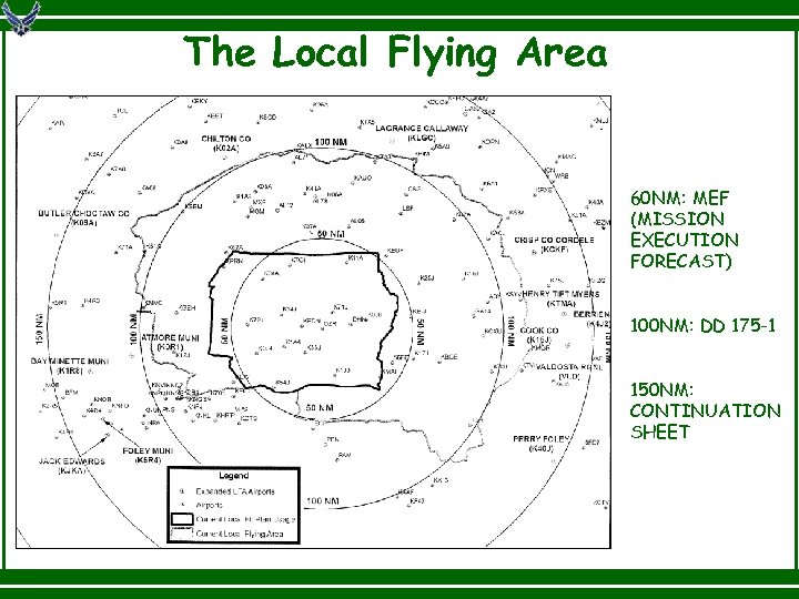
The Local Flying Area 60 NM: MEF (MISSION EXECUTION FORECAST) 100 NM: DD 175 -1 150 NM: CONTINUATION SHEET
Weather Equipment – Cairns AAF FMQ-19 An automated system that automatically generates observations Supplemented/backed up by forecaster IAW Air Force directives LOCAL observations no longer exist

Weather Equipment – Cairns AAF FMQ-19 supplemented per AF policy Supplement: To manually provide wx elements that are beyond the system’s capability to measure/report Tornado/Funnel Cloud/Waterspout Volcanic Ash Sandstorms/Duststorms Hail Ice Pellets Snow Depth
Weather Equipment – Cairns AAF FMQ-19 backed up per AF policy Back up: To manually provide wx elements when automated sensors are malfunctioning and are operationally significant Wind speed/direction Visibility/present wx Temperature/dew point Sky cover up to and including 25, 000 ft Altimeter Lightning location Layer of clouds or obscuration below 600 ft

Weather Equipment – Cairns AAF JET (Joint Environmental Toolkit) Web-based system that integrates ATC/Ops/Wx functions Area observations; WWAs; altimeter; and winds Available to Base Fields, ARAC, HUB via AAAS Available to Stage Fields via internet
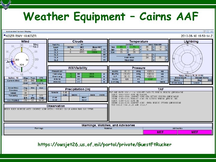
Weather Equipment – Cairns AAF https: //owsjet 26. us. af. mil/portal/private/Guest. Ft. Rucker

Weather Equipment – Lowe AHP ASOS (Automated Surface Observing System) An automated system that automatically generates observations FMQ-13 Measures wind speed/direction at the Tower JET is available via AAAS

Weather Equipment – Hanchey AHP ASOS (Automated Surface Observing System) An automated system that automatically generates observations FMQ-13 Measures wind speed/direction at the Tower JET is available via AAAS

Weather Equipment – Shell AHP TMOS (Tactical Meteorological Observing System) An automated system that automatically generates observations FMQ-13 Measures wind speed/direction at the Tower JET is available via AAAS
Weather Equipment – Stage Fields FMQ-13 Measures wind speed/direction at the Tower JET is available via internet
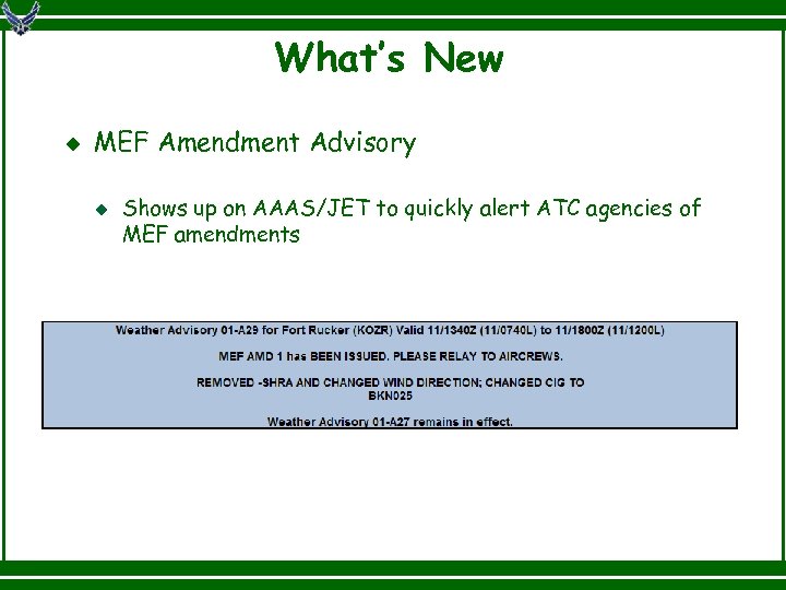
What’s New MEF Amendment Advisory Shows up on AAAS/JET to quickly alert ATC agencies of MEF amendments

What’s New Weather Information Frequency (WIF) FRWXOPS will broadcast details about all MEF amendments on 348. 8 (VHF) PMSV frequency of 134. 1 (UHF) remains unchanged
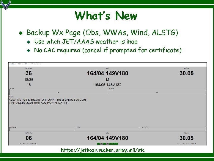
What’s New Backup Wx Page (Obs, WWAs, Wind, ALSTG) Use when JET/AAAS weather is inop No CAC required (cancel if prompted for certificate) https: //jetkozr. rucker. army. mil/atc
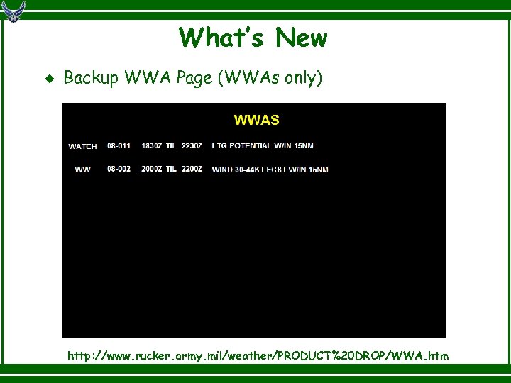
What’s New Backup WWA Page (WWAs only) http: //www. rucker. army. mil/weather/PRODUCT%20 DROP/WWA. htm

What’s New Social Media Twitter (@ftruckerwx) Facebook (ftruckerwx) Free Mobile App (www. ftrucker. mobi) Why social media? Fastest way to get wx updates at remote locations

Types of Observations METAR A routine scheduled observation that contains a complete report of wind, visibility, runway visual range, present weather and obscurations, sky condition, temperature, dew point, and altimeter. Reported between 55 and 59 past each hour. SPECI An unscheduled observation completed and transmitted as soon as possible when any special criteria has been observed. Contain all data elements found in a METAR plus additional remarks that elaborate on data in the body of the report. Decoded just like a METAR

Observations Let’s look at an example KOZR METAR 1155 Z AUTO 22010 G 17 KT 1/2 SM +RA BR FEW 004 BKN 008 OVC 015 04/04 ALSTG 30. 06 RMK PA +172 DA +41 AO 2 RAB 1115 P 0013 60051 70155 T 00380037 53002

Observations KOZR METAR 1155 Z AUTO 22010 G 17 KT 1/2 SM +RA BR FEW 004 BKN 008 OVC 015 04/04 ALSTG 30. 06 RMK PA +172 DA +41 AO 2 RAB 1115 P 0013 60051 70155 T 00380037 53002 This is an hourly (METAR) report for Cairns AAF (KOZR).

Observations KOZR METAR 1155 Z AUTO 22010 G 17 KT 1/2 SM +RA BR FEW 004 BKN 008 OVC 015 04/04 ALSTG 30. 06 RMK PA +172 DA +41 AO 2 RAB 1115 P 0013 60051 70155 T 00380037 53002 The time of the observation is the 1155 Z.

Observations KOZR METAR 1155 Z AUTO 22010 G 17 KT 1/2 SM +RA BR FEW 004 BKN 008 OVC 015 04/04 ALSTG 30. 06 RMK PA +172 DA +41 AO 2 RAB 1115 P 0013 60051 70155 T 00380037 53002 The observation is from an automated reporting site.

Observations KOZR METAR 1155 Z AUTO 22010 G 17 KT 1/2 SM +RA BR FEW 004 BKN 008 OVC 015 04/04 ALSTG 30. 06 RMK PA +172 DA +41 AO 2 RAB 1115 P 0013 60051 70155 T 00380037 53002 The winds are from 220° (SW) at 10 knots (KT) with gusts (G) to 17.

Observations KOZR METAR 1155 Z AUTO 22010 G 17 KT 1/2 SM +RA BR FEW 004 BKN 008 OVC 015 04/04 ALSTG 30. 06 RMK PA +172 DA +41 AO 2 RAB 1115 P 0013 60051 70155 T 00380037 53002 The visibility is 1/2 statute miles (SM).

Observations KOZR METAR 1155 Z AUTO 22010 G 17 KT 1/2 SM +RA BR FEW 004 BKN 008 OVC 015 04/04 ALSTG 30. 06 RMK PA +172 DA +41 AO 2 RAB 1115 P 0013 60051 70155 T 00380037 53002 The present weather is heavy rain (+RA) and mist (BR).

Observations KOZR METAR 1155 Z AUTO 22010 G 17 KT 1/2 SM +RA BR FEW 004 BKN 008 OVC 015 04/04 ALSTG 30. 06 RMK PA +172 DA +41 AO 2 RAB 1115 P 0013 60051 70155 T 00380037 53002 The sky condition is FEW at 400 feet (FEW 004), BKN at 800 feet (BKN 008), and overcast at 1500 feet (OVC 015). Note: cloud bases are reported in AGL.

Observations KOZR METAR 1155 Z AUTO 22010 G 17 KT 1/2 SM +RA BR FEW 004 BKN 008 OVC 015 04/04 ALSTG 30. 06 RMK PA +172 DA +41 AO 2 RAB 1115 P 0013 60051 70155 T 00380037 53002 The temperature is 04°, and the dew point is 04° (Celsius).

Observations KOZR METAR 1155 Z AUTO 22010 G 17 KT 1/2 SM +RA BR FEW 004 BKN 008 OVC 015 04/04 ALSTG 30. 06 RMK PA +172 DA +41 AO 2 RAB 1115 P 0013 60051 70155 T 00380037 53002 The altimeter is 30. 06. One of the quirks of AAAS is that it drops any trailing zeroes in the altimeter. For instance, an altimeter of 30. 10 would show up as 30. 1.

Observations KOZR METAR 1155 Z AUTO 22010 G 17 KT 1/2 SM +RA BR FEW 004 BKN 008 OVC 015 04/04 ALSTG 30. 06 RMK PA +172 DA +41 AO 2 RAB 1115 P 0013 60051 70155 T 00380037 53002 The remarks include: Pressure Altitude (PA +172) Density Altitude (DA +41) Both of these are in ft.

Observations KOZR METAR 1155 Z AUTO 22010 G 17 KT 1/2 SM +RA BR FEW 004 BKN 008 OVC 015 04/04 ALSTG 30. 06 RMK PA +172 DA +41 AO 2 RAB 1115 P 0013 60051 70155 T 00380037 53002 The AO 2 indicates the observation is generated from an automated system with no human intervention. AO 2 A would indicate that the observation is being augmented.

Observations KOZR METAR 1155 Z AUTO 22010 G 17 KT 1/2 SM +RA BR FEW 004 BKN 008 OVC 015 04/04 ALSTG 30. 06 RMK PA +172 DA +41 AO 2 RAB 1115 P 0013 60051 70155 T 00380037 53002 The rest of the remarks are generally useless outside the Weather Station. Rain Began at 1115 Z.

Observations KOZR METAR 1155 Z AUTO 22010 G 17 KT 1/2 SM +RA BR FEW 004 BKN 008 OVC 015 04/04 ALSTG 30. 06 RMK PA +172 DA +41 AO 2 RAB 1115 P 0013 60051 70155 T 00380037 53002 The hourly precipitation amount was. 13”.

Observations KOZR METAR 1155 Z AUTO 22010 G 17 KT 1/2 SM +RA BR FEW 004 BKN 008 OVC 015 04/04 ALSTG 30. 06 RMK PA +172 DA +41 AO 2 RAB 1115 P 0013 60051 70155 T 00380037 53002 The 6 -hourly precipitation was. 51”.

Observations KOZR METAR 1155 Z AUTO 22010 G 17 KT 1/2 SM +RA BR FEW 004 BKN 008 OVC 015 04/04 ALSTG 30. 06 RMK PA +172 DA +41 AO 2 RAB 1115 P 0013 60051 70155 T 00380037 53002 The 24 -hourly precipitation was 1. 55”.

Observations KOZR METAR 1155 Z AUTO 22010 G 17 KT 1/2 SM +RA BR FEW 004 BKN 008 OVC 015 04/04 ALSTG 30. 06 RMK PA +172 DA +41 AO 2 RAB 1115 P 0013 60051 70155 T 00380037 53002 The temperature and dew point, on the hour, were 3. 8° and 3. 7° (Celsius).

Observations KOZR METAR 1155 Z AUTO 22010 G 17 KT 1/2 SM +RA BR FEW 004 BKN 008 OVC 015 04/04 ALSTG 30. 06 RMK PA +172 DA +41 AO 2 RAB 1115 P 0013 60051 70155 T 00380037 53002 This is the pressure tendency group, reported every 3 hours.

SPECI Criteria A SPECI is required when the ceiling crosses the following thresholds: 3000 feet 2000 feet 1500 feet 1000 feet 800 feet 700 feet 600 feet 500 feet 400 feet 300 feet 200 feet 100 feet A layer of clouds or obscuring phenomena aloft is present at or below 600 feet and no layer was reported in the preceding METAR or SPECI.

SPECI Criteria A SPECI is required when the prevailing visibility crosses the following thresholds: 3 SM 2 SM 1 ½ SM 1 ¼ SM 1 SM ¾ SM ½ SM ¼ SM

SPECI Criteria A SPECI is required when: A thunderstorm begins or ends A squall occurs. A squall is when the wind speed suddenly increases by 16 knots or more and exceeds 22 knots for at least 1 minute. Wind shift. The wind direction changes of 45° or more in less than 15 minutes with sustained winds or gusts of 10 knots or more throughout the shift.

SPECI Criteria A SPECI is required when: Hail begins or ends Freezing precipitation begins, ends, or changes intensity Any other type of precipitation begins or ends

SPECI Criteria A SPECI is required when the Runway Visual Range (RVR) from the active runway (RWY 06) crosses the following thresholds: 2000 feet 2400 feet 4000 feet 5000 feet 6000 feet RVR conditions are unavailable (RVRNO), are first determined, or when RVRNO is no longer applicable. Prevailing visibility is first observed to be ≤ 1 SM and again when prevailing visibility goes above 1 SM

SPECI Criteria A SPECI is required when: A tornado or funnel cloud appears or disappears from sight Note: Because the KOZR observations are automated and a running log is archived, a SPECI is NOT required for an aircraft accident/mishap unless the FMQ-19 is down.

Pilot Reports (PIREPs) A PIREP is defined as a report of meteorological phenomena encountered by aircraft in flight Required fields include Message type Location Time Flight Level Aircraft type One other element such as Sky cover Weather Temperature Winds Hazards (Turbulence, Icing)

Pilot Reports (PIREPs) All PIREPs received by ATC agencies must be passed immediately to the Weather Station Let’s look at an example. KOZR UA /OV KEDN 090025/TM 1245/FL 020/TP H 60/SK SCT 005 -TOP 010 BKN-OVC 015 -TOPUNKN/ WX FV 03 SM -RA/TA 05/WV 18015 KT/RM LIGHT CHOP ON TAKEOFF

Pilot Reports (PIREPs) KOZR UA /OV KEDN 090025/TM 1245/FL 020/TP H 60/SK SCT 005 -TOP 010 BKN-OVC 015 -TOPUNKN/ WX FV 03 SM -RA/TA 05/WV 18015 KT/RM LIGHT CHOP ON TAKEOFF The PIREP was disseminated by Cairns AAF (KOZR).

Pilot Reports (PIREPs) KOZR UA /OV KEDN 090025/TM 1245/FL 020/TP H 60/SK SCT 005 -TOP 010 BKN-OVC 015 -TOPUNKN/ WX FV 03 SM -RA/TA 05/WV 18015 KT/RM LIGHT CHOP ON TAKEOFF The PIREP is routine in nature (UA). UUA would indicate an urgent report.

Pilot Reports (PIREPs) KOZR UA /OV KEDN 090025/TM 1245/FL 020/TP H 60/SK SCT 005 -TOP 010 BKN-OVC 015 -TOPUNKN/ WX FV 03 SM -RA/TA 05/WV 18015 KT/RM LIGHT CHOP ON TAKEOFF The PIREP was from an aircrew located 25 SM E (090025) of Enterprise (KEDN).

Pilot Reports (PIREPs) KOZR UA /OV KEDN 090025/TM 1245/FL 020/TP H 60/SK SCT 005 -TOP 010 BKN-OVC 015 -TOPUNKN/ WX FV 03 SM -RA/TA 05/WV 18015 KT/RM LIGHT CHOP ON TAKEOFF The time of the PIREP was 1245 Z.

Pilot Reports (PIREPs) KOZR UA /OV KEDN 090025/TM 1245/FL 020/TP H 60/SK SCT 005 -TOP 010 BKN-OVC 015 -TOPUNKN/ WX FV 03 SM -RA/TA 05/WV 18015 KT/RM LIGHT CHOP ON TAKEOFF The flight level was 2000 feet (020).

Pilot Reports (PIREPs) KOZR UA /OV KEDN 090025/TM 1245/FL 020/TP H 60/SK SCT 005 -TOP 010 BKN-OVC 015 -TOPUNKN/ WX FV 03 SM -RA/TA 05/WV 18015 KT/RM LIGHT CHOP ON TAKEOFF The aircraft type was a H-60.

Pilot Reports (PIREPs) KOZR UA /OV KEDN 090025/TM 1245/FL 020/TP H 60/SK SCT 005 -TOP 010 BKN-OVC 015 -TOPUNKN/ WX FV 03 SM -RA/TA 05/WV 18015 KT/RM LIGHT CHOP ON TAKEOFF The sky condition was a SCT layer with bases at 500 feet and tops at 1000 feet; and a BKN to OVC layer with bases at 1500 feet and tops unknown.

Pilot Reports (PIREPs) KOZR UA /OV KEDN 090025/TM 1245/FL 020/TP H 60/SK SCT 005 -TOP 010 BKN-OVC 015 -TOPUNKN/ WX FV 03 SM -RA/TA 05/WV 18015 KT/RM LIGHT CHOP ON TAKEOFF The flight visibility was 3 SM (FV 03 SM) due to light rain (RA).

Pilot Reports (PIREPs) KOZR UA /OV KEDN 090025/TM 1245/FL 020/TP H 60/SK SCT 005 -TOP 010 BKN-OVC 015 -TOPUNKN/ WX FV 03 SM -RA/TA 05/WV 18015 KT/RM LIGHT CHOP ON TAKEOFF The temperature was 05° Celsius.

Pilot Reports (PIREPs) KOZR UA /OV KEDN 090025/TM 1245/FL 020/TP H 60/SK SCT 005 -TOP 010 BKN-OVC 015 -TOPUNKN/ WX FV 03 SM -RA/TA 05/WV 18015 KT/RM LIGHT CHOP ON TAKEOFF The wind was from 180° (S) at 15 KT (knots).

Pilot Reports (PIREPs) KOZR UA /OV KEDN 090025/TM 1245/FL 020/TP H 60/SK SCT 005 -TOP 010 BKN-OVC 015 -TOPUNKN/ WX FV 03 SM -RA/TA 05/WV 18015 KT/RM LGT CHOP ON TAKEOFF; SCUD LAYER TO EAST Remarks can include anything else the pilot added. In this example, the remarks are: Light chop on takeoff and the pilot observed a scud layer to the east.

Wind direction is “fromsie” Wind speed is reported in knots (KT) A “G” means gust Let’s look at a few examples: 22012 KT From the SW at 12 KT 31009 KT From the NW at 09 KT VRB 05 KT 18012 G 24 KT Variable at 05 KT From the S at 12 KT with gust of 24 KT

Visibility The prevailing visibility determined from the designated point of observation (the sensor itself) Reported in statute miles (SM) No more sector visibility

Visibility Markers Daytime markers Prominent, dark colored objects Fixed objects Nighttime markers Unfocused light of moderate intensity Fixed objects NOTE: Moving aircraft are NOT an acceptable method of determining visibility. Only fixed objects for which the distance is known may be used (ie objects from your approved visibility chart).

Present Wx Reported for any phenomenon that reduces prevailing visibility to ≤ 6 SM Classified as precipitation or obscuration

Present Wx Obscurations Mist Fog Smoke Volcanic Ash Dust Sand Haze Spray BR FG FU VA DU SA HZ PY Visibility ≥ 5/8 SM Visibility < 5/8 SM

Present Wx Precipitation Types Drizzle Rain Snow Grains Ice Crystals Ice Pellets Large Hail Small Hail Snow Pellets DZ RA SN SG IC PL GR GS GS ≥ ¼ inch < ¼ inch

Present Wx Intensity or Proximity No Symbol + VC Light Moderate Heavy In the vicinity
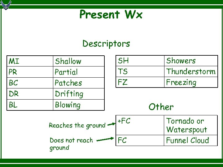
Present Wx Descriptors MI PR BC DR BL Shallow Partial Patches Drifting Blowing Reaches the ground Does not reach ground SH TS FZ Showers Thunderstorm Freezing Other +FC FC Tornado or Waterspout Funnel Cloud

Present Wx Let’s look at some examples. FZRA RA +TSRA BLDU VCTS -SHRA TS Freezing Rain Moderate Rain Thunderstorm with Heavy Rain Blowing Dust Thunderstorms in the Vicinity Light Rain Showers Thunderstorm (no Rain)

Sky Condition Sky Cover SKC/CLR FEW SCT BKN OVC Sky Clear Trace to 2/8 coverage 3/8 to 4/8 coverage 5/8 to 7/8 coverage 8/8 coverage Cloud Ceiling

Sky Condition Let’s look at some examples. BKN 110 BKN at 11, 000 feet AGL SCT 009 BKN 040 OVC 210 SCT at 900 feet, BKN at 4000 feet, and OVC at 21, 000 feet AGL VV 001 Vertical visibility into a total obscuration, in this case 100 feet AGL

Sky Condition Ceiling is defined as the lowest broken or overcast layer, or the vertical visibility into a surface-based obscuration that totally hides the sky (i. e. an indefinite ceiling) Let’s look at some examples. VV 001 SCT 002 BKN 007 OVC 010 BKN 015 OVC 028 BKN 120 100 feet 700 feet 1500 feet 12, 000 feet

Limited Observations When evaluating tower visibility: Evaluate as frequently as practical Use all available markers Visibility Checkpoint Charts must be reviewed by Wx Station annually or when the visibility chart changes

Limited Observations (Tornadic Activity) A waterspout is defined as a violently rotating column of air that touches the water A tornado is defined as a violently rotating column of air that touches the ground A funnel cloud is defined as a violently rotating column of air that does not touch the ground

Cooperative Weather Watch Weather units are required to establish a cooperative weather watch with ATC as required. Of primary concern is The report of tower visibility different from the prevailing surface visibility Local PIREPs Any weather event that could affect flight safety

Cooperative Weather Watch Certified tower personnel at Cairns AAF will notify the Weather Station: When changing active runways When changing the runway center light settings When the prevailing visibility at the tower is < 4 SM (6000 meters) When thunderstorms or precipitation begins or ends When fog or mist is observed Anytime a PIREP is received

Cooperative Weather Watch Certified tower personnel at the Base Fields should notify the Weather Station: When the cig/vis goes IFR and differs from the Cairns AAF ob When a cloud ceiling crosses the 500 ft threshold When visibility crosses the ½ SM threshold When thunderstorms or precipitation begins or ends When fog or mist is observed When winds exceed 25 kts, 35 kts, and 50 kts Anytime a PIREP is received

Cooperative Weather Watch Certified tower personnel at the Stage Fields should notify the Weather Station: When precipitation begins or ends When fog or mist is observed When winds equal or exceed 25 kts, 35 kts, and 50 kts Anytime a PIREP is received

Watch vs Warning vs Advisory A weather watch means watch out---potential exists A weather warning means there is imminent danger A weather advisory means there is weather that could impact flight operations

Watch vs Warning vs Advisory Fort Rucker’s Weather Watches are issued for a 60 NM ring (except for Lightning, which is for a 15 NM ring) Fort Rucker’s Weather Warnings are issued for a 15 NM ring (except Lightning, which is for a 5 NM ring) Fort Rucker’s Weather Advisories are issued for either a 15 NM ring (terminal) or a 60 NM ring (area)

Wx Watch Criteria (60 NM) Tornado LTG w/in 15 NM Damaging Winds (> 45 kts) Severe Thunderstorms (> 45 kts and/or Hail > ½”) Heavy Rain (> 2” in 12 hrs) Freezing Precipitation Snowfall (> ½” accumulation)

Wx Warning Criteria (15 NM) Tornado LTG w/in 5 NM Severe Thunderstorms (> 45 kts and/or Hail > ½”) Moderate Thunderstorms (30 -44 kts and/or Hail < ½”) Damaging Winds (> 45 kts ) Strong Winds (30 -44 kts) Heavy Rain (> 2” in 12 hrs) Freezing Precipitation Snowfall (≥ ½” accumulation)

Area Wx Advisory Criteria (60 NM) Forecast severe or extreme TURBC blo 10 K ft Observed moderate or greater TURBC blo 10 K ft Forecast icing blo 10 K ft Winds ≥ 20 kts Observed snow falling blo 2 K ft Forecast Predominant Low IFR (< 500/1)

Area Wx Advisory Criteria (60 NM) LLWS blo 2 K ft Observed 1500/5 in Goldfish N 1 Observed IFR (< 1000/3) N 1 Forecast Predominant IFR (< 1000/3) N 1 Forecast Thunderstorm IFR (< 1000/3)

Terminal Wx Advisory Criteria (15 NM) Wind gust spread ≥ 15 kts Cross winds ≥ 25 kts at Cairns AAF Temps ≤ 00°C for 5 or more hrs Temps ≤ M 06°C

Terminal Wx Advisory Criteria (15 NM) LTG observed w/in 10 NM of KOZR N 1 Observed IFR (< 1000/3) N 1 Forecast Predominant IFR (< 1000/3) N 1 Forecast Thunderstorm IFR (< 1000/3) Forecast Predominant Low IFR (< 500/1)

Off-Site WWAs LTG observed w/in 5 NM of KLOR LTG observed w/in 5 NM of KHEY LTG observed w/in 5 NM of KSXS LTG observed w/in 5 NM of KFHK LTG observed w/in 5 NM of 19 AL (Molinelli FARP)

Conclusion Weather Equipment What’s New Observations METAR SPECI Pilot Reports Cooperative Weather Watches/Warnings/Advisories

Test Time Please notify Cindy Howell (5 -8142) if you have any questions or feedback about this course. As part of your Initial Weather Certification and Annual Recertification, you must take and pass a written exam with 70% or above. Test is open book. Tower Chiefs, please remember to email your memos to Cindy Howell (cindy. l. howell. civ@mail. mil) each time you certify new folks. Slides Updated on 02 Dec 13

How To Reach Us On the WWW @ http: //www. rucker. army. mil/6 weather/index. htm Give us a call @ 8385 or 8397 (or HOTLINE) Facebook (ftruckerwx) Twitter (@ftruckerwx) Mobile App (www. ftrucker. mobi) Come on down and see us!
6544642e50de664fa3e3d0004a69045a.ppt