

a02c610e1f8c850ba08f1931f99bdbd9.ppt
- Количество слайдов: 30
 An introduction to Geographic Information and why it is important Brian Higgs Corporate GIS Manager Birmingham 18 th November
 What is Geography? • Spatial is one of only five ways to analyse information Obvious • Where is my nearest library or doctors surgery? • How many households are there within 2 km of the proposed recycling centre? • Where do the pupils who attend a particular school actually live? Less so • Who is my councillor? • When does my bin get emptied? • Synergy – the ability to join up data about the same real world object or individual.
 GI as a Facilitator • Modern society now depends on seemingly limitless numbers of computerised databases. • Bank/credit details, store cards, insurance and health records, Facebook and other internet applications, etc… • Most of these contain some form of geo-code that can be linked to reference geographies, eg nearly 90% of Local Authority databases fall into this category.
 SWIFT Social Service Clients ELMS 2 Community Equipment NLIS Land Charges Business Link Data Northgate - ASPIRE - Revenues and Benefits CRM (Dudley Council Plus) EMS Early Years Northgate Electoral Register CENTRIS Pupil Records EXPERIAN MOSAIC UK GIS and LLPG M 3/Northgate Environmental Health ONS Census Data ONS Exe. Ges. IS - i. World – HBSMR Housing Management APAS Planning Applications back to 1947 MAYRISE - GVA - Street Lighting Corporate Asset Management Building Reg’s TPO’s Enforcements Planning Policy Symology - CONFIRM - Highways Maintenance Arbor / Grounds Maintenance SIDEM – Parking Management Index of Multiple Deprivation
 Reference Geographies • Postcode Designed to be a mail delivery mechanism not a reference geography, but everyone knows theirs • Address As above but factors such as “gentrification” make the ability to match difficult so resort to property references • Transportation networks Roads, railways, canals, rivers etc. Different communities will often see the same object differently • Co-ordinates Different co-ordinate systems require translation such as data captured through GPS (latitude/longitude) to be mapped on O. S. maps (National Grid)
 Local Authority applications using spatial technologies
 500 m radius search area
 Customer Insight and Social Marketing We already know which of our services they use, so collate the service lines through the address in order to build up a profile of the customer… Type Age Tenure Address Individual Social Services Pupil Records Electoral Register CRM etc Household Business Housing Benefit Housing Council Benefit Council Housing Environmental Health Trading Standards Trade Waste Rating Non-Domestic Rating CRM etc
 A GI-based approach to getting to know your Customer Insight and Social Marketing customer Where they live will give some insight into their demographic profile and identify services that aren’t being taken up but perhaps should be, using sources such as: Profiling data e. g. IMD Local Authority and partner data Commercially available data, e. g. MOSIAC
 Mosaic data
 Reproduced from O. S. mapping with the permission of The Controller of H. M. S. O. Crown Copyright 2009 Licence No. 100019566
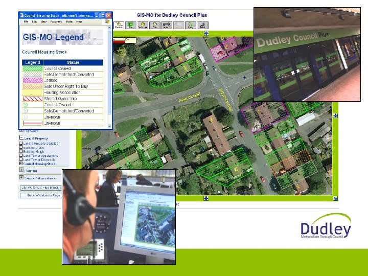
 GIS-MO for Schools All 110 schools have accessed it with Primary Schools the most active users One user interface from Reception Class through to Sixth Form Supports crosscurricular delivery The first application to be delivered through Dudley Schools Portal
 Other sector applications
 Retail Sector • Planning the location of new stores using geo-demographics, e. g. analyses of catchments and drive-times • Loyalty cards enable them to monitor what you buy and from where; assists planning of promotions and reducing unsold stock
 Insurance Sector – Flood Risk
 Health Sector
 Public-facing applications
 Health Services
 Government
 Route Planning
 Fault Reporting
 Open Access Mapping Infrastructure
 Geography has “broken out” Neo-geographers • our view of them: • their view of us:
 Because it’s there to be mapped… Locations of places mentioned in one band’s songs
 Validating and improving authoritative data – despite the authorities!
 Community calendar – where and when
 Historical information German V 2 rocket strikes on London
 Thank you for your attention