

AIS KMA.pptx
- Количество слайдов: 34
 AIS Automatic Identification System KMA Deck Officers Year 1 2012 - 2013 A. I. S.
 A. I. S.") Automatic Identification System (A. I. S. ) A. I. S.
Automatic Identification System (A. I. S. ) A. I. S.
 Topics 1. 1 1. 2 1. 3 1. 4 1. 5 Gain an appreciation of the legal framework Gain an understanding of the basics of A. I. S. operation Understand the advantages of the system Understand the dis-advantages of the system Understand the limitations of the system A. I. S.
 annex 3) 1.") What is it? Automatic Identification System According to IMO (MSC 74(69) annex 3) 1. In the ship to ship mode, to assist in collision avoidance 2. As a means for states to obtain information about ships and their cargoes 3. As a VTS tool (ship-shore for vessel traffic management) …. also Radar target broadcasting, VTS waypoints/route plan, Transmission of met or hydrographic info, Info about aids to navigation, Psuedo aids to navigation A. I. S.
What is it? Automatic Identification System According to IMO (MSC 74(69) annex 3) 1. In the ship to ship mode, to assist in collision avoidance 2. As a means for states to obtain information about ships and their cargoes 3. As a VTS tool (ship-shore for vessel traffic management) …. also Radar target broadcasting, VTS waypoints/route plan, Transmission of met or hydrographic info, Info about aids to navigation, Psuedo aids to navigation A. I. S.
 1. 1 Legal obligation Chapter V Safety of Navigation Regulation 19 - Automatic Identification System : 2. 2. 2. 4 All ships > 300 gt same requirements as Passenger ships, tankers and ships>500 gt as of 1 July 2004 or at first safety equipment survey after 1 July 2004. Latest 31 December 2004 2. 2. 2. 7 AIS in operation at all times A. I. S.
 Why AIS ? “Ship on") 1. 2 Automatic Identification System (A. I. S. ) Why AIS ? “Ship on my port side, ship on my port side, get out of my way! That’s why! A. I. S.
1. 2 Automatic Identification System (A. I. S. ) Why AIS ? “Ship on my port side, ship on my port side, get out of my way! That’s why! A. I. S.
 Typical AIS panels A. I.") 1. 2 Automatic Identification System (A. I. S. ) Typical AIS panels A. I. S.
1. 2 Automatic Identification System (A. I. S. ) Typical AIS panels A. I. S.
 A. I. S.") 1. 2 Automatic Identification System (A. I. S. ) A. I. S.
1. 2 Automatic Identification System (A. I. S. ) A. I. S.
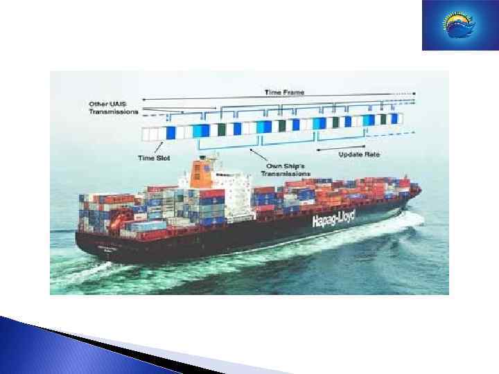
 1. 2 A. I. S. a few basics • AIS is basically a VHF (Very High Frequency) radio communications system, operating on marine-band frequencies A. I. S.
 A. I. S.
") Principle based on TDMA Time Division Multiple Access In a TDMA system (like GSM) time is divided in short timeslots. Every user has his own slot. Usually a system like this is managed by a central manager from a network. 11
Principle based on TDMA Time Division Multiple Access In a TDMA system (like GSM) time is divided in short timeslots. Every user has his own slot. Usually a system like this is managed by a central manager from a network. 11
 Ships at sea have no network system available. Solution is found in the fact that GPS receivers have a very accurate time signal available EVERY AIS SYSTEM IS EQUIPTED WITH A GPS RECEIVER USED FOR TIMESYNCHRONISATION. 12
 There are 3 operating modes 1. SOTDMA 2. FATDMA 3. POLLING 13
 1. SOTDMA Self Organized Time Division Multiple Access Autonomous mode: System “looks ahead in time” in order to give new (incoming) stations a chance to find a free timeslot HOW? All users on that frequency and that time frame include time of next transmission in their information message. RESULT! No incoming user is going to use that slot. Completely independent self organizing local system. (No shore/sat. management needed) 14
 2. FATDMA Fixed Access Time Division Multiple Access Competent authorized user divides the timeslots (USUALLY VTS-AIS STATION) between users. This can be useful to increase the broadcast of dynamic information for selected users. The VTS station also reserves timeslots to send its own messages on a regular basis.
 3. Polling Mode Also called interrogation mode. One user asks another user to send a certain message. 17
 Technical description AIS station 2 types: Class-A: Ships under SOLAS. AIS station has to comply with IMO standard. Class-B: Ships not under SOLAS AIS station may comply with IMO standard. 18
GPS: Used for time synchronization. Can") Class-A station DGPS POWER UNIT PROCESSOR 2 VHF (D)GPS: Used for time synchronization. Can be used as a back-up for positioning. Position info is taken from bridge navigation system. Power Unit: 24 Volt from a UPS. (Battery) Processor: Generates messages and handles info stream (inputoutput) 2 VHF Units. Both listening one sending 19
Class-A station DGPS POWER UNIT PROCESSOR 2 VHF (D)GPS: Used for time synchronization. Can be used as a back-up for positioning. Position info is taken from bridge navigation system. Power Unit: 24 Volt from a UPS. (Battery) Processor: Generates messages and handles info stream (inputoutput) 2 VHF Units. Both listening one sending 19
 one can not use the normal AIS frequencies. Solution:") In some cases (North America) one can not use the normal AIS frequencies. Solution: every AIS station has a channel 70 DSC receiver build in to take care of local AIS frequency change over. CLASS-B STATIONS 20
In some cases (North America) one can not use the normal AIS frequencies. Solution: every AIS station has a channel 70 DSC receiver build in to take care of local AIS frequency change over. CLASS-B STATIONS 20
 1. 2 AIS information STATIC DYNAMIC Voyage related MMSI Number Position Ships draught Call-sign Time UTC Hazardous Ca. Name COG/SOG Destination Type of ship. Heading ETA Location transp. Nav. Status Route plan. Dimensions ship Rate of turn Accuracy info. A. I. S.
 1. 2 Update rates of AIS Static Info: Every 6 minutes Dynamic Info: Depends on speed and course alteration Voyage related info: Every 6 mins, at data amendments and on request. Safety related messages: As requested. A. I. S.
 1. 2 A. I. S. information Position report, message 1, 2, 3 • MMSI • Position in latitude and longitude • Course Over Ground • Speed Over Ground • Position accuracy • Rate of Turn • Heading • Time stamp • Navigational status • Under way • at anchor • not under command • restricted manoeuvrability • constrained by draught • moored Ship at anchor, not moving or < 3 knots 3 minutes • aground Ship at anchor, moving faster than 3 knots 10 seconds • fishing Ship 0 -14 knots 10 seconds • sailing Ship 0 -14 knots, changing course 3, 3 seconds • …. . Ship 14 -23 knots 6 seconds Ship 14 -23 knots, changing course 2 seconds Ship > 23 knots 2 seconds A. I. S.
 1. 2 A. I. S. information Ship Static and Voyage related data, message 5 • MMSI • IMO number • Call sign • Name • Type of ship 20 WIG 30 Vessel, fishing 31 “ towing 32 “ towing > 200 m 33 “ dredging / underwater operation 34 “ diving operation 35 “ military operation 36 “ sailing 37 “ pleasure craft 40 HSC 50 Pilot vessel 51 Search and rescue 52 Tug 53 Port tender 54 Vessel with anti-pollution facilities 55 Law enforcement vessel 56, 57 local 58 Medical transport 59 Ship according Resolution 18 (Mob-83) 60 Passenger ship 70 Cargo ship 80 Tanker 90 Other ship A. I. S.
 1. 2 A. I. S. information Ship Static and Voyage related data, message 5 • MMSI • IMO number • Call sign • Name • Type of ship • Type of Electronic Position Fixing Device GPS GLONASS Combined GPS / GLONASS LORAN-C CHAYKA Integrated Navigation System …. A. I. S.
 1. 2 A. I. S. information Ship Static and Voyage related data, message 5 • MMSI • IMO number • Call sign • Name • Type of ship • Type of Electronic Position Fixing Device • Reference point for reported position C D B A A. I. S.
 1. 2 A. I. S. information Ship Static and Voyage related data, message 5 • Present Static Draught • Destination • ETA • Type of Cargo Carrying Dangerous Goods, Harmful Substances, or Marine Pollutants 1 IMO category A 2 IMO category B 3 IMO category C 4 IMO category D A. I. S.
 1. 3 A. I. S. plus points +++ • Pilot use – Communication with VTS • Improved situational awareness • Overcome problem of “target swapping” • Unambiguous identification of radar targets • Ability to “see” around bends or behind a landmass • Detect vessels that might otherwise be hidden in another vessel’s radar shadow • Real time information about other ship’s movements (e. g. , speed +/-, rate of turn) • Detect a change in another ship's heading without waiting for ARPA calculations A. I. S.
 1. 3 A. I. S. display A. I. S.
 1. 4 A. I. S. minus points -- • Not all ships/boats have AIS fitted • AIS can be turned off • Need for regular checking to ensure data transmitted is correct • Possible display overload for OOW • Radar Sea Stabilised v AIS Ground Stabilised • Open system (can endanger vessel i. e. piracy, 9/11) A. I. S.
 1. 5 A. I. S. leading to complacency link to 1. 5. 1 A. I. S. assisted collision Hyundai Dominion and Sky Hope 21 June 2004 p. 28 A. I. S.
 1. 5 AIS options voluntary or short range +/- 25 nm A. I. S.
 1. 5 A. I. S. is not L. R. I. T. Long Range Identification and Tracking link to 1. 5. 3 L. R. I. T. link to 1. 5. 4 eulrit A. I. S.
 - www. maib. gov. uk") Acknowledgements - Maritime Education Platform (M. E. P. ) - www. maib. gov. uk - Kelvin Hughes - The Nautical Institute Seaways July, September 2009 - www. mackaycomm. com - Heijden van der Wim F. M. . AIS long-range ship reporting. IMO/IALA Seminar on AIS session 4 paper 3 extract - EMSA A. I. S.
Acknowledgements - Maritime Education Platform (M. E. P. ) - www. maib. gov. uk - Kelvin Hughes - The Nautical Institute Seaways July, September 2009 - www. mackaycomm. com - Heijden van der Wim F. M. . AIS long-range ship reporting. IMO/IALA Seminar on AIS session 4 paper 3 extract - EMSA A. I. S.