

8995015a0eea3696763e8f9f7ebdb7fe.ppt
- Количество слайдов: 59
 ADM Geographic Information System GIS Shared Services Review and Recap of Phase 3– GIS SSC Committee Eastern Cape 12 September 2014 Chris Carter carterc@mhpgeospace. co. za MHP Geo. Space (Eastern Cape)
 Shared Service Centre In 2013 a fully functional GIS shared services centre was established to service both the DM and all 7 LMs. Since most LMs cannot afford GIS personnel, the DM increased its staff capacity to provided a full and equitable service to the LMs The services on offer are: • Map Production (standard and customised maps) • Data Distribution (Analysis and data updates) • Online Information (GIS Website : www. amatholegis. gov. za) • Advisory Service (for spatial components of tenders and data validation) • Training (basic GIS training) • Data maintenance (cadastral and facilities data) • Scope and implement GIS projects on the behalf of lms.
 Service Level Agreement Proposed GIS SSC Service Level Agreement
 ADM GIS SECTION • Currently there are 5 permanent staff members. • 2 GIS operators which support the 2 GIS technicians and one GIS specialist.
 NXUBA, GREAT KEI, MNQUMA AND MBASHE MUNICIPALITIES
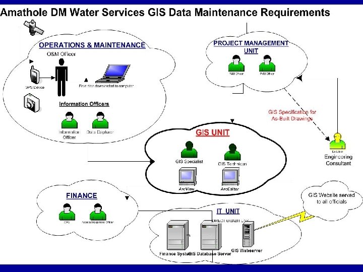
 ADM GIS INFRASTRUCTURE
 COMMUNITY FACILITY DATA CAPTURE • ADM initiated a project in June 2011 to capture facility information it thought to be important to address the business needs of the DM and it’s LM’s. • A combined effort was undertaken by the DM together with it’s LM’s, the ward councillors, local community and a consultant to implement the project.
 User Requirement Analysis in 2010 : Priorities
 Capture Form
 Schedule of Quantities Captured per facility type Total Facilities = 6754
 Facilities Capture-Emergency Service
 LAND AUDIT Cadastral Data Acquisition & Capture
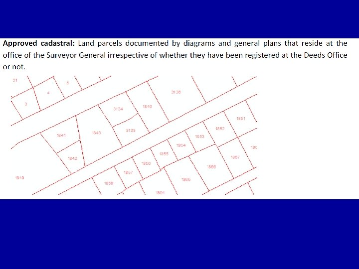
 ADM Cadastral Land Audit • Full cadastral audit of all registered and SGapproved properties with SG 21 Digit Codes were created. • Checking and correcting the SG information for spatial and attributes inaccuracies using small scale diagrams and general plans
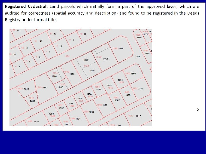
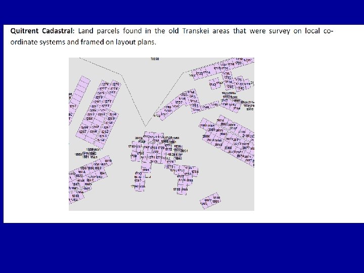
 Land Audit Data Maintained by ADM • SG approved cadastral in GIS format • Registered cadastral layer in GIS format • Unregistered Cadastral layer in GIS format • Quitrent cadastral layer in GIS format • Deeds Office ownership datasets for properties in MS access format • Deeds office ownership datasets for complex units/sectional titles in MS access format
 Land Audit Deeds Office Ownership Information Linkage
 Follow on work from the Cadastral Land Audit Data • Ø Ø Ø Audit valuation roll against property register Find properties missing in the valuation roll Find ghost properties in the valuation roll Use corrected valuation roll to correct financial and billing databases • Audit Land Use Management Plans against property Register • Quarterly maintenance system to keep data up-to date with the Deeds Registry and SG ‘s Office (January 2014) • Spatial linkage to the financial ADM system for water revenue enhancement. This resulted in a further exercise to update the land use management plans, due the findings between the local municipality valuation roll zoning information and that which existed on the DM Venus database
 LAND USE Original formats of the land use plans-PDF
 Original formats of the land use plans-Excell
 Original formats of the land use plans-TIFF
 Incorporation of data from various formats to GIS and published on the website
 LUMS update • Initiated from the revenue enhance project • It was found that there were inconsistencies between the Venus billing zone information and that picked up from the LM valuation data sets. • Sessions were held between MSU planning manager and the GIS unit to find ways to resolve some of the issues faced at LM level • GIS unit assisted the MSU unit with adding a clause to all tender specifications that went out for town planning. MSU was also made aware that the ADM GIS unit had a more updated approved layer than what consultants acquire from the SG office.
 LM Amahalthi Great Kei Nxuba Mnquma Nkonkobe Ngqushwa Mbashe Town Cathcart Stutterheim Keiskammahoek Kei Road Cintsa Glen Eden Glen Gariff Haga Kei Mouth Komga Morgans Bay Bedford Adelaide Nqamakwe Butterworth Centane Alice Middledrift Seymour Fort Beaufort Hamburg Peddie Elliotdale Idutywa Willowvale Land use old scheme received received old scheme not received received received Zoning none received received none not received received received
 Current LUMS Status • All data supplied has been consolidated into the Audited Approved Layer. • Amahlathi landuse is based on the draft 2012 plans and not zone information has been supplied • Data for Mnquma was received but was in a incomplete state and we had to bring this to the attention of the service provider • All other lm’s was matched best to what was supplied. • It has to be noted that the consultants responsible for the LUMS data are still using old layers and this has now resulted in queries which have to be addressed with either the planner or the lm itself. • What has also been noted is that across different muncipalities the landuse and zone information is referred to differently
 Land use info across LMs Zone info across LMs
 Data from planning consultant Audited approved cadastral Mar 2014
 ADM Street Capture • Using the most recent cadastral data- street addresses were assigned per property. • The street name and the most accurate numbers were used from the various sources of data.
 Data Source
 LM Amahlathi Great") • Various sources of information resulted in : (Desktop exercise) LM Amahlathi Great Kei Mbashe Mnquma Ngqushwa Nkonkobe Nxuba No. Parcels 10044 7165 3165 8920 4971 16040 6919 • Desktop exercise resulted in a 70% to 80% match • Most land parcels in the townships took on the erf numbers • The town centres were most complicated. The actual situation on the ground is not in line with the registered cadastral. • Many “own consolidations” have happened and have not be registered and owners have come up with there own house numbers. • Postal services occur to cluster boxes and not individual homes.
• Various sources of information resulted in : (Desktop exercise) LM Amahlathi Great Kei Mbashe Mnquma Ngqushwa Nkonkobe Nxuba No. Parcels 10044 7165 3165 8920 4971 16040 6919 • Desktop exercise resulted in a 70% to 80% match • Most land parcels in the townships took on the erf numbers • The town centres were most complicated. The actual situation on the ground is not in line with the registered cadastral. • Many “own consolidations” have happened and have not be registered and owners have come up with there own house numbers. • Postal services occur to cluster boxes and not individual homes.
 Study Area
") Example of the Road Stick Map in Alice (Nkonkobe LM)
Example of the Road Stick Map in Alice (Nkonkobe LM)
 Examples of Street Addressing-Alice
 Problems with the Addressing
 Result of work done Nkonkobe : Adelaide
 Financial Analysis of ADM Water Accounts using GIS • Completion of the Land Audits instantly enabled detailed and accurate analysis to be done on ADM water account data • The analysis required not only ADM water account data but also Local Municipal valuation roll (containing the property zonings) and rating databases in order to validate the zoning and property information recorded at LM level. • Link between spatial (GIS) property data and financial system data necessitated creation of the SG 21 -digit code in the financial data
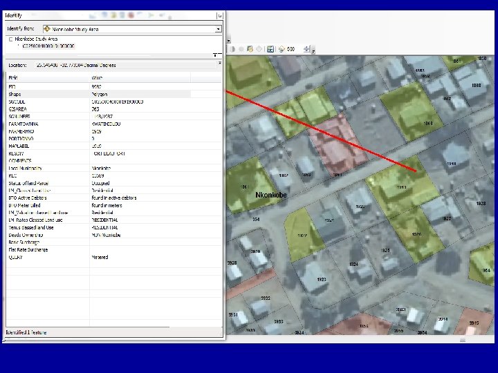
 • ADM study area is indicated in Red
 related to Municipal Valuation Roll") Spatial relationship: Land parcel (erf 32) related to Municipal Valuation Roll
Spatial relationship: Land parcel (erf 32) related to Municipal Valuation Roll
 Various input data used for the analysis Layer Name Source Total Land Parcels Format Registered Cadastral ADM 68 255 GIS shapefile Venus-Active Debtors ADM 75 743 Excel Venus-Meter Billing ADM 28 352 Excel General Valuations LM'S 74 093 Excel Water Flat Rate BTO 1442 Excel Water Basic service BTO 34865 Excel Rates LM'S 75611 Excel
 d re te is eg R xc l(e tra as C ad er at W es e ic at R rv e R at Se at Fl c si Ba er at W ns at io lu Va s llin g Bi to r d) la n eb D et er M al er en G s e e at st tiv Ac d an nu Ve s s fa rm Ve nu g in lu d Number of land parcels per layer type 80000 70000 60000 50000 40000 30000 20000 10000 0
 80000 70000 land parcels 60000 50000") Cadastral linkage to various spread sheets (mismatch report) 80000 70000 land parcels 60000 50000 40000 30000 20000 10000 0 Registered Cadastral(excludin g farms an. . . Total land parcels 68255 % mismatch to cad Venus Active Debtors General Valuations Rates Venus Meter Billing 75743 26% 74093 11% 58834 30% 28352 37%
Cadastral linkage to various spread sheets (mismatch report) 80000 70000 land parcels 60000 50000 40000 30000 20000 10000 0 Registered Cadastral(excludin g farms an. . . Total land parcels 68255 % mismatch to cad Venus Active Debtors General Valuations Rates Venus Meter Billing 75743 26% 74093 11% 58834 30% 28352 37%
 Number of land parcels with percentages of meters not being read. land parcels with no meter readings Total land parcels %age 68255 25506 13482 37% reg cad no meter reading found 20% occupied with no meter readings
 GIS Desktop Capture –Property Status
 Sample financial data-Venus Active Debtors
 Sample financial data-LM Valuations
 Sample financial data-Meter Billing
 Sample financial data-Consumptions
 Conclusion: Estimated water revenue loss per month per Local Municipality The residential registered properties account for majority of the revenue loss amounting to R 2 517 525. 40 over its 6493 registered properties. 2 nd are vacant properties, which according to the tariffs should be billed for.
 Potential revenue loss by land use type recorded in Venus Land Use Type Residential Vacant Unknown Government Business Commercial Institution Government( Residential) Industrial Total Occupied sites with no meter or reading taken Monthly Potential Revenue Lost 6493 R 2 517 525. 40 4633 R 339 832. 56 2895 R 222 683. 40 116 R 218 061. 60 131 49 R 205 878. 82 R 83 294. 46 289 R 76 523. 20 17 R 36 214. 08 14623 R 3 700 013. 52
 Reasons for Underbilling for Water in ADM • Registered and occupied properties not included in the financial system for a variety of reasons • Registered and occupied properties supplied with water but not having meters or meters not being read • Properties being recorded in the financial system with incorrect land use types or the land use types are captured as “unknown” • Properties being recorded in the financial system with incorrect ownership type (eg private instead of commercial) • Bills not being issued for vacant privately owned properties over which services exist for these
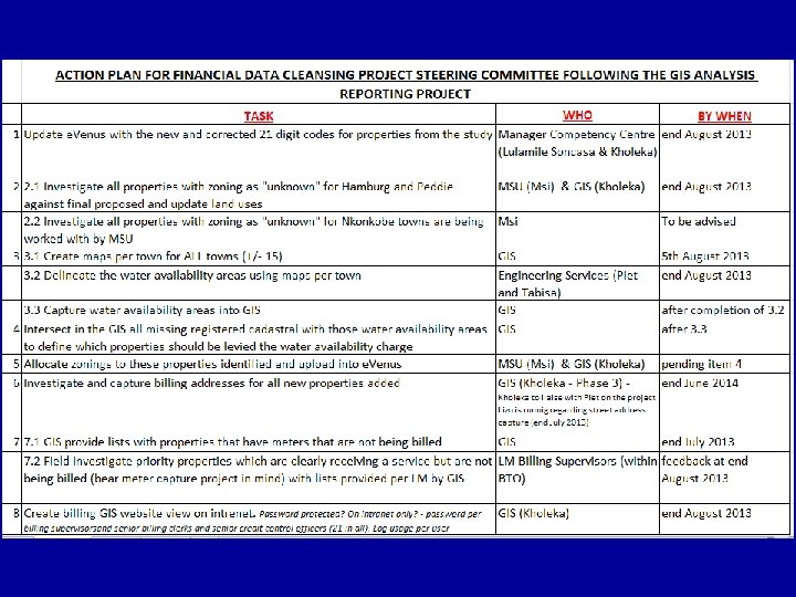
 correct data errors, 2)") Recommendations • Major cleansing of data must commence immediately: 1) correct data errors, 2) resolve land use anomalies, 3) include missing properties, 4) investigate on ground where no meters and non-billing is apparent, 5) issue bills for vacant privately owned properties over which services exist (requires quick audit of service infrastructure i ADM GIS and service areas to be captured in GIS) • 21 digit codes must be retained and updated in e. Venus in order to facilitate analysis quarterly and check how we’re doing • Land Use residing in both the District and Local Municipality information systems must be exactly the same and a work flow must be implemented to have this done and updated quarterly between LMs and ADM. • The meter service coverage data set must be captured an implementation plan enforced to maintain this data.
Recommendations • Major cleansing of data must commence immediately: 1) correct data errors, 2) resolve land use anomalies, 3) include missing properties, 4) investigate on ground where no meters and non-billing is apparent, 5) issue bills for vacant privately owned properties over which services exist (requires quick audit of service infrastructure i ADM GIS and service areas to be captured in GIS) • 21 digit codes must be retained and updated in e. Venus in order to facilitate analysis quarterly and check how we’re doing • Land Use residing in both the District and Local Municipality information systems must be exactly the same and a work flow must be implemented to have this done and updated quarterly between LMs and ADM. • The meter service coverage data set must be captured an implementation plan enforced to maintain this data.
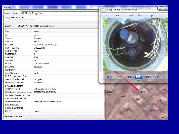
 ADM METER SURVEY SCOPE OF WORK : • Visit each water meter/s serving each registered Erf • Using a sub-meter accurate GPS, record the position of the meter • Record whether the erf is vacant or occupied. • Record type of meter. • Record the status of the water connection. • Record the meter serial number/s of the meter/s supplying that Erf • Record the actual meter reading of the meter/s • Record date and time of the reading. • Take a photo of the meter/s number/s. • Record the type of Sanitation connected to each registered erf and indicate where there is no service. • Record the street address of the property.
 Making the information available to all: ADM’s GIS Website: www. amatholegis. gov. za • Available 24/7 • Allows everyone to query, view and print maps in a simple to use environment • TABLET VERSION: http: //gis 6. mhpgeospace. co. za/Amathole. JS/
 Thank You