

2a73e5ccba7ca34d510263a42c429e62.ppt
- Количество слайдов: 79
. Please allow") A kind reminder on distractions such as phone use, noise (see syllabus). Please allow fellow students to focus. E. G. please always turn off your cell phone or put it on vibrate mode for class GIS for environmental management Dr. William James Smith, Jr. Assistant Professor of Environmental Studies, UNLV Adjunct Assistant Professor in Geography, The University of Iowa
A kind reminder on distractions such as phone use, noise (see syllabus). Please allow fellow students to focus. E. G. please always turn off your cell phone or put it on vibrate mode for class GIS for environmental management Dr. William James Smith, Jr. Assistant Professor of Environmental Studies, UNLV Adjunct Assistant Professor in Geography, The University of Iowa
. -PPT -Masking") Today’s agenda -“How are you doing? ” survey (I expect grad/undergrad diffs). -PPT -Masking rivers and roads with basins or graphics demo VS using graphic or shape to cut with or without geoprocessor -Exam study guide -I need to spare time because I need to meet anyone who missed last class. -Previous corrupted file for exercise 9 rescued and repaired, please download from Web. CT to your exercises and labs folder. Report any Ch. 11 “building” file problems to me. -Do your work from your book during lab time
Today’s agenda -“How are you doing? ” survey (I expect grad/undergrad diffs). -PPT -Masking rivers and roads with basins or graphics demo VS using graphic or shape to cut with or without geoprocessor -Exam study guide -I need to spare time because I need to meet anyone who missed last class. -Previous corrupted file for exercise 9 rescued and repaired, please download from Web. CT to your exercises and labs folder. Report any Ch. 11 “building” file problems to me. -Do your work from your book during lab time
 -PPT -Masking") Today’s agenda -“How are you doing? ” (I expect grad/undergrad diffs. ) -PPT -Masking rivers and roads with basins or graphics demo VS using graphic or shape to cut with or without geoprocessor -Exam study guide -Report any Ch. 11 “building” file problems to me. -Do your work from your book during lab time -Grooming you for a manager’s role
Today’s agenda -“How are you doing? ” (I expect grad/undergrad diffs. ) -PPT -Masking rivers and roads with basins or graphics demo VS using graphic or shape to cut with or without geoprocessor -Exam study guide -Report any Ch. 11 “building” file problems to me. -Do your work from your book during lab time -Grooming you for a manager’s role
 Sources of map data: hard copy and digital This should also help you think of your posters/PPTs for later!
 Core GIS lab and RIAP for $75 k
 Three categories for data acquisition: 1. Data already exists digitally and is purchased or otherwise acquired. 2. Data exists on paper only and geocoding is necessary. 3. The map does not exist, and remote sensing is necessary (more later).
 1. Finding Existing Map Data • • • Map libraries (what to do with/ maps older than GIS? !) Reference books State and local agencies Federal agencies Commercial data suppliers e. g. GDT, Thompson, ETAK E. g. What do you think you could do with an old whaling map with small islands on it?
 Research libraries often support cartographic research and may have thematic map collections (e. g. hydrology, historical, etc. ). Examples of books that can provide references (e. g. ): -Map Catalog by John Makower -Maps for America by Thompson (USGS) -Inventory of World Topographic Mapping by Bohme -Map Use and Analysis by Campbell
 2. GEOCODING • Geocoding is the conversion of spatial information into digital form • Geocoding involves capturing the map, and sometimes also capturing the attributes • Often involves address matching (kind of confusing how this is used sometimes)
 EPSCo. R Native American List
 address matching: Using a street address such as 123 Main Street in conjunction with a digital map to place a street address onto the map in a known location. Address matching a mailing list, for example, would convert the mailing list to a map and allow the mapping of characteristics of the places on the list.
 analog: A representation where a feature or object is represented in another tangible medium. For example, a section of the earth can be represented in analog by a paper map -- thus “analog VS. digital” in text You may geocode for the conversion of analog maps into computer readable-form. Two main methods of geocoding are scanning and digitizing.
 GEOCODING LEAVES A “STAMP” ON DATA • The method of geocoding can influence the structure and error associated with the spatial information resulting • Example: scanning (raster), digitizing (vector)
 Geocoding methods for maps • Digitizing • Scanning • Field data collection
 maps vs. virtual maps Mylar or paper to numbers. Geocoding may but") Real (analog) maps vs. virtual maps Mylar or paper to numbers. Geocoding may but provide for the conversion of spatial information into computer-readable form -- you can get data without it, but big $! Finding the right maps, converting these to virtual form via geocoding takes between 60%-90% of time and money for many GIS projects. But once it is done you can repeatedly use it.
Real (analog) maps vs. virtual maps Mylar or paper to numbers. Geocoding may but provide for the conversion of spatial information into computer-readable form -- you can get data without it, but big $! Finding the right maps, converting these to virtual form via geocoding takes between 60%-90% of time and money for many GIS projects. But once it is done you can repeatedly use it.
 Digitizing • Captures map data by tracing lines from a map by hand • Uses a cursor and an electronically-sensitive tablet • Result is a string of points with (x, y) values
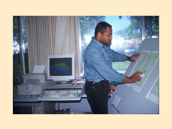
 The Digitizing Tablet Geocoding by tracing over a map with a cursor is sometimes called semiautomated digitizing.
 1. Digitizer cursor transmits a pulse from an electromagnetic coil under the view lens (other types exist). 2. Pulse is picked up by nearest grid wires under tablet surface 3. Result is sent to computer after conversion x & y units.
 • • Stable base map Fix to tablet Digitize control Determine coordinate transformation Trace features Proof plot Edit Clean and build
 • • • Cursor data entry Voice command entry Point select Stream mode Distance mode
 First preprocess the physical material Then tape down the maps Afterwards use known locations as digitizing control points to register the map to the tablet (use coordinates in geocoded coordinate space e. g. lat/long. You need, AT MINIMUM, 3 points, e. g upper right easting and northing, the lower left easting and northing and at least one other corner. Why at least 3? ! Start digitizing by tracing out the map features you are interested in. E. G. After digitizing, then enter attributes. Areas such as lakes are usually digitized as lines, with snapping sometimes being automatic for the last point. It is EASY to let human error create big, but normal looking errors.
 Selecting points to digitize
 Some common digitizing errors • • • Slivers Duplicate lines Duplicate nodes Unended lines Gaps
 Scanning • Places a map on a glass plate, and passes a light beam over it • Measures the reflected light intensity • Result is a grid of pixels • Image size and resolution are important • Features can “drop out”
 Scanning • • Flat bed Drum DPI File size
 Scanning The drum scanner is most commonly used technology. It receives an entire map sheet clamped to a rotating drum, and scans the map with very fine inrements of distance. Obviously, the better the resolution, the higher the cost and the larger the data sets. You may have to preprocess data for recognition of specific cartographic data. You can also use automatic line follower scanners (good for contours).
 Scale and resolution E. G. You have a 7. 5 -minute USGS quadrangle map, and on it is a square of 100 millimeters on a side. The map is 1: 24, 000 -- so the distance is 24, 000 Xs 100 = 2, 4000, 000 millimeters. . . or 2, 400 meters. If you scan you will deal with dots per square inch (DPI), and the higher the DPI the better (more pixels for a given area), and thus, better resolution. If a scan is at too low a resolution and each pixel must represent a relatively large area on the ground, then a feature might “dropout” and be lost or turned into background noise. QC is vital! PG 112 Clarke
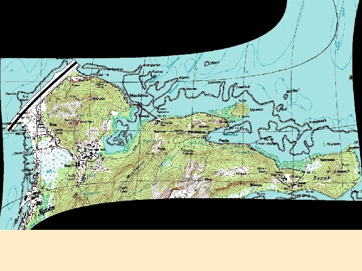
 Scanning example
 Field data collection
 Field and image data Control points are established, and then additional locations, tracing out features or covering terrain, for example, are dealt with by using instruments that measure angles and distances -- then turning bearings, angles and distances into eastings, northings, and elevations. Some of these instruments/software can write directly to a GIS format (COGO).
 or GPS data collection (not all units are equal)") USGS control points (bench marks) or GPS data collection (not all units are equal) can establish control points. Do you know of any bench marks in LV? More on GPS later in the semester
USGS control points (bench marks) or GPS data collection (not all units are equal) can establish control points. Do you know of any bench marks in LV? More on GPS later in the semester
 Database Management Systems • Data definition module sets constraints on the attribute values • To enter and correct values • For storage and retrieval • Legal data definitions can be listed as a data dictionary
 Database elements • • • Type of value Range Missing data Duplicate data Key Attribute_labels = “ID #”, “Feature”, “Name” , “Surface” , “Lanes”, “Traffic “per hour” “ 1”, “Road”, “US 11”, “tarmac”, “ 3”, “ 113”
 At a minimum, data and lines can be processed automatically") Editing and validation (QC) At a minimum, data and lines can be processed automatically for consistency, and unconnected lines or unclosed polygons detected. Know your GIS to know the error messages, procedures, etc. Again, slivers, lines not ended and unsnapped notes are concerns. Spikes are when 0 or really large numbers appear by error. Squashed sections of map may be related to bad control points.
Editing and validation (QC) At a minimum, data and lines can be processed automatically for consistency, and unconnected lines or unclosed polygons detected. Know your GIS to know the error messages, procedures, etc. Again, slivers, lines not ended and unsnapped notes are concerns. Spikes are when 0 or really large numbers appear by error. Squashed sections of map may be related to bad control points.
 Checking the results against an independent map is helpful. Most GIS can generate data listings / data reports listing the attributes as a table, or formatting them neatly for printing and checking. This helps with QC. A DB for NYC had more than 20 spellings for a st! Rivers can=powerlines You may be able to generate maps to check e. g. with the id in the area or next to a line. But positional error can be crucial. Errors on the paper map are duplicated or worsened!
 Data dictionary is the term for the complete listing of relevant info Importing data and “linking” it to existing attribute tables is possible. You must use a file that separates data in a way the GIS understands (you will do this in your book). There are differences in GIS flexibility in operating with spreadsheet packages.
 The Role of Error • Enforcement for map data is usually by using topology • Map and attribute data errors are the data producer's responsibility, but the GIS user must understand error • Accuracy and precision of map and attribute data in a GIS affect all other operations, especially when maps are compared across scales
 Digital sources: Some great ones for your posters / PPTs! • Existing map data can be found via research networks www. aag. org. • Many major data providers make their data available via the World Wide Web, a network of file servers available over the Internet, or on media such as CD-ROM and disk. • GIS vendors package data with products. *Check your syllabus too!
 Also, see links from groups like ESRI,") Commercial vendors (sometimes just improving public data) Also, see links from groups like ESRI, AAG.
Commercial vendors (sometimes just improving public data) Also, see links from groups like ESRI, AAG.
 Early data on networks: Archie Veronica WAIS Gopher Mosaic
 Federal Data Agencies National Spatial Data Infrastructure • • USGS http: //nsdi. usgs. gov/ NOAA Census Bureau The National Geospatial-Intelligence Agency (An agency of the US Department of Defense that manages and provides imagery and geospatial information for diverse military, civil, and international needs. ) http: //www. intelligence. gov/1 -members_nima. shtml http: //www. intelligence. gov/1 -members_nima_products. shtml • Environmental Protection Agency http: //www. epa. gov/nsdi/ • many more. . .
 l Spatial Data Infrastructure http: //www. fgdc. gov/ http: //gos 2. geodata. gov/wps/portal/gos
 National Spatial Data Clearinghouse
 USGS: National Mapping
") USGS, as part of the National Mapping Program provides: 1. Digital line graphs (DLG) 2. Digital elevation models (DEM) 3. Land-use and land-cover digital data derived from remote sensing 4. Digital cartographic text (Geographic Names Information Systems) 5. Digital orthophotoquads 6. Digital raster graphics (DRG) FTP can be helpful (demo? ) E. G. A great global data set is the Digital Chart of the World, which is a digital version of the Defense Mapping Agency’s operational navigation chart at a scale of 1: 1, 000. Search the USGS Earth Science Information Centers online to see more. *Your data library on your computer
USGS, as part of the National Mapping Program provides: 1. Digital line graphs (DLG) 2. Digital elevation models (DEM) 3. Land-use and land-cover digital data derived from remote sensing 4. Digital cartographic text (Geographic Names Information Systems) 5. Digital orthophotoquads 6. Digital raster graphics (DRG) FTP can be helpful (demo? ) E. G. A great global data set is the Digital Chart of the World, which is a digital version of the Defense Mapping Agency’s operational navigation chart at a scale of 1: 1, 000. Search the USGS Earth Science Information Centers online to see more. *Your data library on your computer
 U. S. Bureau of the Census
 U. S. Bureau of the Census In 1990 developed the topologically integrated geographic encoding and referencing system, or TIGER. It uses the block or street segment as a geographic building block, and has the ability to address match to a place on a map. This is available because the Census worked with the USGS to digitize.
 NOAA Weather and other data
 NOAA Its maps must be carried by all large ships in U. S. waters. See the National Geophysical Data Center e. g. for bathymetry (demo? ).
 Goleta, CA, 1967 Image") CORONA (KH Satellites) Goleta, CA, 1967 Image
CORONA (KH Satellites) Goleta, CA, 1967 Image
 Eros Data Center • Distributed active archive center • Sioux Falls, SD • Operated by USGS • Demo • http: //edcwww. cr. usgs. gov/produ cts/landcover/glcc. html
 Image and remote sensing data USGS orthophotos and satellite images are most common. E. G. the National Aerial Photography Program and private vendors. http: //edc. usgs. gov/guides/napp. html http: //edcsns 17. cr. usgs. gov/finder_main. pl? dataset_name=NAPP Digital orthophotos are at an equivalent of 1: 12, 000 and have 1 meter ground resolution. CLASS what does this mean and what should/should not show up. DEMO
 US Geo. Data ftp access to DEM DLG LU and LC demo http: //edc. usgs. gov/geodata/ http: //www. geo. cornell. edu/grad s/duncan/topo/ http: //www. truflite. com/
 GNIS Feature locations
 GIRAS Land Use and Land Cover Data demo http: //edcwww. cr. usgs. gov/products/landcover. html http: //edcwww. cr. usgs. gov/products/landcover/ndvi. html
") GIRAS into Arc/Info (GIRASARC)
GIRAS into Arc/Info (GIRASARC)
 DCW Terrain data DEM DLG Contours http: //edcwww. cr. usgs. gov/Free_Orthorectified. html
 University departments compile lists and serve data demo http: //ncl. sbs. ohio-state. edu/5_sdata. html
 Your Spatial Data “Rights” • US Federal – FOIA http: //www. usgs. gov/foia/ – Cost of fulfilling user requirement (COFUR) South African SD example http: //72. 14. 207. 104/search? q=cache: WAZWi-Zz. Ycg. J: www. nsif. org. za/ http: //www. africagis 2005. org. za/agp/ • State (e. g. California, Teale Data Center) • Local (e. g. Portland, OR Metro) • Other countries • Protection for security • Attributes vs. map data
 REVIEW THESE ON YOUR OWN Terms address matching: Using a street address such as 123 Main Street in conjunction with a digital map to place a street address onto the map in a known location. Address matching a mailing list, for example, would convert the mailing list to a map and allow the mapping of characteristics of the places on the list. analog: A representation where a feature or object is represented in another tangible medium. For example, a section of the earth can be represented in analog by a paper map, or atoms can be represented by ping-pong balls. attribute: A characteristic of a feature that contains a measurement or value for the feature. Attributes can be labels, categories, or numbers; they can be dates, standardized values, or field or other measurements. An item for which data are collected and organized. A column in a table or data file. data dictionary: A catalog of all the attributes for a data set, along with all the constraints placed on the attribute values during the data definition phase. Can include the range and type of values, category lists, legal and missing values, and the legal width of the field.
 data entry: The process of entering numbers into a computer, usually attribute data. Although most data are entered by hand, or acquired through networks, from CDROMs, and so on, field data can come from a GPS receiver, from data loggers, and even by typing at the keyboard. data-entry module: The part of a database manager that allows the user to enter or edit records in a database. The module will normally both allow entry and modification of values, and enforce the constraints placed on the data by the data definition. digitizing: Also called semi-automated digitizing. The process in which geocoding takes place manually; a map is placed on a flat tablet, and a person traces out the map features using a cursor. The locations of features on the map are send back to the computer every time the operator of the digitizing tablet presses a button. digitizing tablet: A device for geocoding by semiautomated digitizing. A digitizing tablet looks like a drafting table but is sensitized so that as a map is traced with a cursor on the tablet and the locations are identified, converted to numbers, and sent to the computer. drop-out: The loss of data due to scanning at coarser resolution than the map features to be captured. Features smaller than half the size of a pixel can disappear
 drum scanner: A map input device in which the map is attached to a drum that is rotated under a scanner while illuminated by a light beam or laser. Reflected light from the map is then measured by the scanner and recorded as numbers. editing: The modification and updating of both map and attribute data, generally using a software capability of the GIS. flat file: A simple model for the organization of numbers. The numbers are organized as a table, with values for variables as entries, records as rows, and attributes as columns. flatbed scanner: A map input device in which the map is placed on a glass surface, and the scanner moves over the map, converting the map into numbers. FTP (File Transfer Protocol): A standardized way to move files between computers. It is a packet switching technique, so that errors in transmission are detected and corrected. FTP allows files, even large ones, to be moved between computers on the Internet or another compatible network gateway: A single entry point to all the servers and other computers associated with one project or organization. For example, the U. S. Geological Survey, though spread across the country and throughout dozens of computers, has a single entry point or gateway into these information sources.
 geocoding: The conversion of analog maps into computer readable-form. The two usual methods of geocoding are scanning and digitizing. Internet: A network of computer networks. Any computer connected to the Internet can share any of the computers accessible through the network. The Internet shares a common mechanism for communication, called a protocol. Searches for data, tools for browsing, and so on ease the tasks of "surfing" the Internet. medium: A map medium is the material chosen on which to produce a map; for example paper, film, mylar, CD-ROM, a computer screen, a TV image, and so on. network: Two or more computers connected together so that they can exchange messages, files, or other means of communication. A network is part hardware, usually cables and communications devices such as modems, and part software. NOAA (National Oceanic and Atmospheric Administration): A part of the Department of Commerce, that is a provider of digital and other maps for navigation, weather prediction, and physical features of the United States. point mode: A method of geocoding in semiautomated digitizing, in which one press of the cursor button sends back to the computer only one (the current) tablet location.
 real map: A map that has been designed and plotted onto a permanent medium such as paper or film. It has a tangible form and is a result of all of the design and compilation decisions made in constructing the map, such as choosing the scale, setting the legend, choosing the colors, and so on. report: A listing of all the values of attributes for all records in a database. A report is often printed as a table, for verification against source material, and for validation by examination. scanning: A form of geocoding in which maps are placed on a surface and scanned by a light beam. Reflected light from every small dot or pixel on the surface is recorded and saved as a grid of digits. Scanners can work in black and white, in gray tones, or in color. server: A computer connected to a network whose primary function is to act as a library of information that other users can share. stream mode: A method of geocoding in semi-automated digitizing, in which a continuous stream of points follows a press of the cursor button. This mode is often used for digitizing long features such as streams and coastlines. It can generate data very quickly, so is often weeded immediately by generalization.
 TIGER: A map data format based on zero, one, and two cells, used by the U. S. Census Bureau in street level mapping of the United States. topology: The numerical description of the relationships between geographic features, as encoded by adjacency, linkage, inclusion, or proximity. Thus a point can be inside a region, a line can connect to others, and a region can have neighbors. The numbers describing topology can be stored as attributes in the GIS and used for validation and other stages of description and analysis. U. S. Census Bureau: A part of the Department of Commerce that provides maps in support of the decennial (every 10 years) census of the United States. USGS (United States Geological Survey): A part of the Department of the Interior and a major provider of digital map data for the United States. validation: A process by which entries placed in records in an attribute data file, and the map data captured during digitizing or scanning, are checked to make sure that their values fall within the bounds expected and that their distribution makes sense. virtual map: A map that has yet to be realized as a tangible map; it exists as a set of possible maps. For example, the same digital base map and set of numbers can be entire series of possible virtual maps, yet only one may be chosen to be rendered as a real map on a permanent medium.
 Additional resources for you follow
 Arc. View GIS Popular desktop mapping and GIS software, by ESRI. Auto. CAD Map® 2000 software is for precision mapping and geographic information system (GIS) analysis in the Auto. CAD® environment. Caliper GIS Software products Home of Maptitude and other desktop GIS and mapping software. CIA World Databank Consortium for International Earth Science Information Network (CIESIN) The Consortium for International Earth Science Information Network. Digital Elevation Data Catalogue This catalogue includes details of elevation and bathymetric data, together with a section on available software for the display and manipulation of these data, maintained by Bruce Gittings. Environmental Protection Agency (EPA) Environmental Protection Agency home page (US).
 US Earth Resources Observation Systems Data Center. ESRI Home") Earth Resources Observation Systems (EROS) US Earth Resources Observation Systems Data Center. ESRI Home for Arc. Info 8 and Arc. View GIS and mapping software. Federal Geographic Data Committee (FGDC) The Federal Geographic Data Committee coordinates the development of the National Spatial Data Infrastructure (NSDI). The 17 federal agencies that make up the FGDC are developing the NSDI in cooperation with organizations from state, local and tribal governments, the academic community, and the private sector. Geographers Craft Geography classes on-line, by Dr. Kenneth E. Foote of the University of Texas at Austin. Geography and GIS Servers Listing A collection of geography-related sites all over the world, maintained at Utrecht University. Geoplace. com Leading provider of Geospatial Information.
Earth Resources Observation Systems (EROS) US Earth Resources Observation Systems Data Center. ESRI Home for Arc. Info 8 and Arc. View GIS and mapping software. Federal Geographic Data Committee (FGDC) The Federal Geographic Data Committee coordinates the development of the National Spatial Data Infrastructure (NSDI). The 17 federal agencies that make up the FGDC are developing the NSDI in cooperation with organizations from state, local and tribal governments, the academic community, and the private sector. Geographers Craft Geography classes on-line, by Dr. Kenneth E. Foote of the University of Texas at Austin. Geography and GIS Servers Listing A collection of geography-related sites all over the world, maintained at Utrecht University. Geoplace. com Leading provider of Geospatial Information.
 GIS Bibliography ESRI Virtual Campus Library contains over 7, 384 GIS references. This list originated at Ohio State University as the GIS Master Bibliography Project. GIS Software Listing This is a general compilation of many of the major Geographic Information Software (GIS) and Geographic Image Processing (GIP) packages currently available. Originally developed by Oliver Weatherbe and now maintained by Vinton Valentine. Global Land Information System (GLIS) GLIS contains references to regional, continental, and global land information including land use, land cover, and soils data; cultural and topographic data; and remotely sensed satellite and aircraft data. Google. com Award-winning search engine. Geographic Resources Analysis Support System (GRASS) GRASS is a GIS with raster, topological vector, image processing, and graphics production functionality that operates in the UNIX environment through a graphical user interface and shell in X-Windows.
 IDRISI is a raster geographic analysis software package, developed by a non-profit research organization within the Graduate School of Geography at Clark University. IDRISI provides an extensive suite of tools for image processing, geographic and statistical analysis, spatial decision support, time series analysis, data display, and import/export and conversion. Intergraph Corporation Home for Geo. Media mapping and /GIS software. Library of Congress Geography and Map Division The Geography and Map Division has custody of the largest and most comprehensive cartographic collection in the world with collections numbering over 4. 5 million maps including 60, 000 atlases, 6, 000 reference works, numerous globes and plastic relief models, and a large number of cartographic materials in other formats, including electronic. These cartographic materials date from fourteenth century portolan charts through recent geographic information systems data sets. Map. Info Home of Map. Info Professional, leading software for mapping and geographic analysis. Map Projections Home Page At this site you will find a collection of information relating to map projections.
 The National Center") NASA Home Page National Center for Geographic Information and Analysis (NCGIA) The National Center for Geographic Information and Analysis is an independent research consortium dedicated to basic research and education in geographic information science and its related technologies. National Geophysical Data Center (NGDC) The National Geophysical Data Center (NGDC), part of the National Oceanic and Atmospheric Administration (NOAA), is the national repository for geophysical data, providing a wide range of science data services and information. National Oceanic and Atmospheric Administration (NOAA) NOAA's Mission is to describe and predict changes in the Earth's environment, and conserve and wisely manage the Nation's coastal and marine resources. Acquire coastal satellite images at this site. National Geospatial Data Clearinghouse (NGDC) The USGS node of the National Geospatial Data Clearinghouse is a component of the National Spatial Data Infrastructure (NSDI). The Clearinghouse provides a pathway to find information about geospatial or spatially referenced data available from USGS.
NASA Home Page National Center for Geographic Information and Analysis (NCGIA) The National Center for Geographic Information and Analysis is an independent research consortium dedicated to basic research and education in geographic information science and its related technologies. National Geophysical Data Center (NGDC) The National Geophysical Data Center (NGDC), part of the National Oceanic and Atmospheric Administration (NOAA), is the national repository for geophysical data, providing a wide range of science data services and information. National Oceanic and Atmospheric Administration (NOAA) NOAA's Mission is to describe and predict changes in the Earth's environment, and conserve and wisely manage the Nation's coastal and marine resources. Acquire coastal satellite images at this site. National Geospatial Data Clearinghouse (NGDC) The USGS node of the National Geospatial Data Clearinghouse is a component of the National Spatial Data Infrastructure (NSDI). The Clearinghouse provides a pathway to find information about geospatial or spatially referenced data available from USGS.
 NSDI encompasses policies, standards, and procedures for organizations to") National Spatial Data Infrastructure (NSDI) NSDI encompasses policies, standards, and procedures for organizations to cooperatively produce and share geographic data. This site includes metadata, and a clearinghouse of geographic data. NCGIA Core Curriculum, New Given the continuing demand for copies of the original 1990 NCGIA Core Curriculum in GIS, the NCGIA has decided that a major revision is warranted. The new Core Curriculum concentrates on providing fundamental course content and lecture materials. NCGIA Core Curricula, Original The original 1990 NCGIA Core Curriculum in GIS. Project Geo. Sim is creating education modules for introductory geography courses. Spatial Data Transfer Standard (SDTS) USGS Spatial Data Transfer Standard (SDTS) information site. Spatial Odyssey Annual Bibliographic GIS Series. Lists conference proceedings and various compendia of interest to GIS researchers.
National Spatial Data Infrastructure (NSDI) NSDI encompasses policies, standards, and procedures for organizations to cooperatively produce and share geographic data. This site includes metadata, and a clearinghouse of geographic data. NCGIA Core Curriculum, New Given the continuing demand for copies of the original 1990 NCGIA Core Curriculum in GIS, the NCGIA has decided that a major revision is warranted. The new Core Curriculum concentrates on providing fundamental course content and lecture materials. NCGIA Core Curricula, Original The original 1990 NCGIA Core Curriculum in GIS. Project Geo. Sim is creating education modules for introductory geography courses. Spatial Data Transfer Standard (SDTS) USGS Spatial Data Transfer Standard (SDTS) information site. Spatial Odyssey Annual Bibliographic GIS Series. Lists conference proceedings and various compendia of interest to GIS researchers.
 is") TIGER See US Census. UNEP/GRID United Nations Environment Program/Global Resource Information Database (UNEP/GRID) is an internationally recognized information center providing decisionmakers and the public with improved access to high quality environmental information. University Consortium for Geographic Information Science (UCGIS) UCGIS is a non-profit organization of universities and other research institutions dedicated to advancing our understanding of geographic processes and spatial relationships through improved theory, methods, technology, and data. U. S. Geological Survey (USGS) World Wide Web gateway for the U. S. Geological Survey. USGS Geographic Information Systems explained What is a GIS? How does a GIS work? What's special about a GIS? And applications of GIS. USGS National Geospatial Data Clearinghouse See National Geospatial Data Clearinghouse.
TIGER See US Census. UNEP/GRID United Nations Environment Program/Global Resource Information Database (UNEP/GRID) is an internationally recognized information center providing decisionmakers and the public with improved access to high quality environmental information. University Consortium for Geographic Information Science (UCGIS) UCGIS is a non-profit organization of universities and other research institutions dedicated to advancing our understanding of geographic processes and spatial relationships through improved theory, methods, technology, and data. U. S. Geological Survey (USGS) World Wide Web gateway for the U. S. Geological Survey. USGS Geographic Information Systems explained What is a GIS? How does a GIS work? What's special about a GIS? And applications of GIS. USGS National Geospatial Data Clearinghouse See National Geospatial Data Clearinghouse.
 US Census TIGER files mapping service World Wide Web gateway for the census TIGER data at the U. S. Census Bureau. The goal of this service is to provide a public resource for generating high-quality, detailed maps of anywhere in the United States, using public geographic data. World Data Bank National statistics for countries and regions, sample maps showing environmental and other data.
 END Unrelated tasks: -Exam review -Masking rivers and roads with basins or graphics demo -VS using graphic or shape to cut with or without geoprocessor
 Attribute data • • Logically can be thought of as in a flat file Table with rows and columns Attributes by records Entries called values
 Data entry -- some considerations Flat files are typically like a table full of numbers. We talked about this before. DEMO STREET FILE TOGETHER The type of value is important e. g. text vs number The range is vital e. g. percentages have to be between ? ? What categories of text, etc. Label a missing value NULL or -999 -- be careful if summing, etc. Are duplicates allowed? E. G. street names. Match exactly what was on paper or have a column to link the two. DEMO MANIPULATION OF THIS