48cf882eeb218c8aaa55777f650f8a8f.ppt
- Количество слайдов: 70
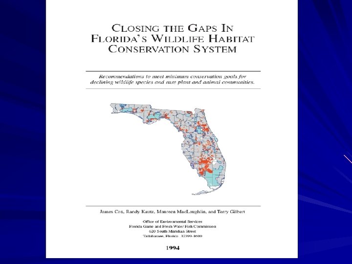
 44 focal species and rare natural communities Florida Natural Areas Inventory, the Florida Game and Fresh Water Fish Commission boundaries of public lands
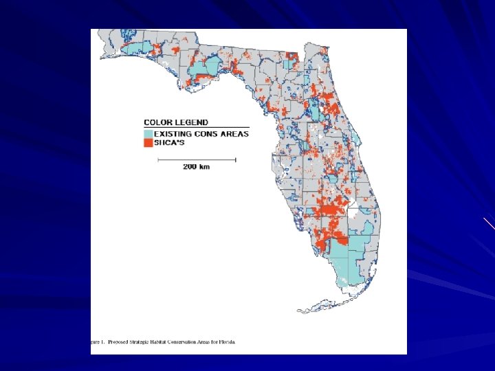
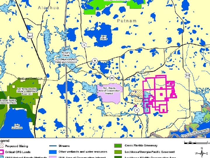
 EXISTING CONSERVATION AREAS
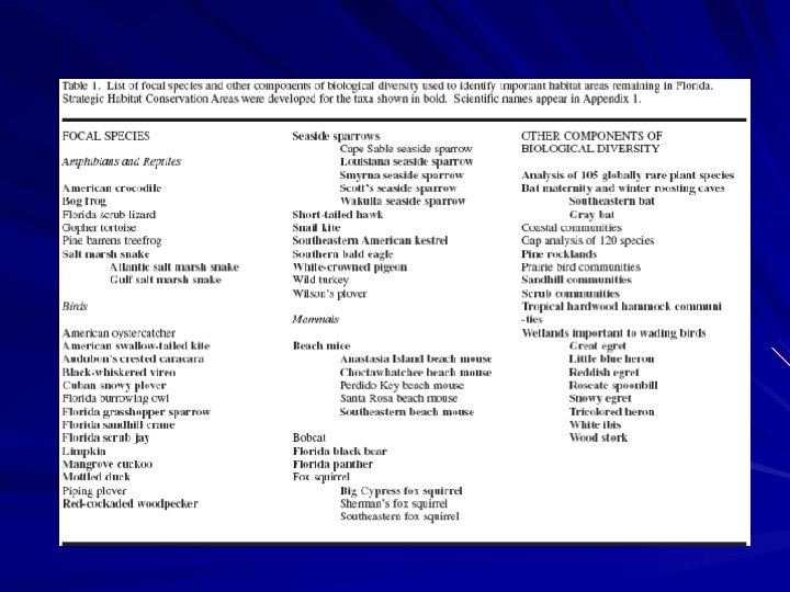
") Sherman’s Fox Squirrel (Sciurus niger shermani )
Sherman’s Fox Squirrel (Sciurus niger shermani )
 (Gopherus polyphemus") The Gopher Tortoise ) (Gopherus polyphemus
The Gopher Tortoise ) (Gopherus polyphemus
") Gopher Frog (Rana capito)
Gopher Frog (Rana capito)
 (Neoseps reynoldsi") Florida Mouse (Podomys floridana Sand Skink ) (Neoseps reynoldsi
Florida Mouse (Podomys floridana Sand Skink ) (Neoseps reynoldsi
 Eastern Indigo Snake (Drymarchon corais couperi
 Of the 40 focal species subjected to this analysis, 30 were found not to have this minimum level of protection on public lands.
 So they then determined those lands that are essential to providing some of the state’s rarest animals, plants, and natural communities with the land base necessary to sustain populations into the future.
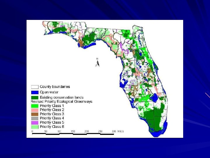
 STRATEGIC HABITAT CONSERVATION AREAS
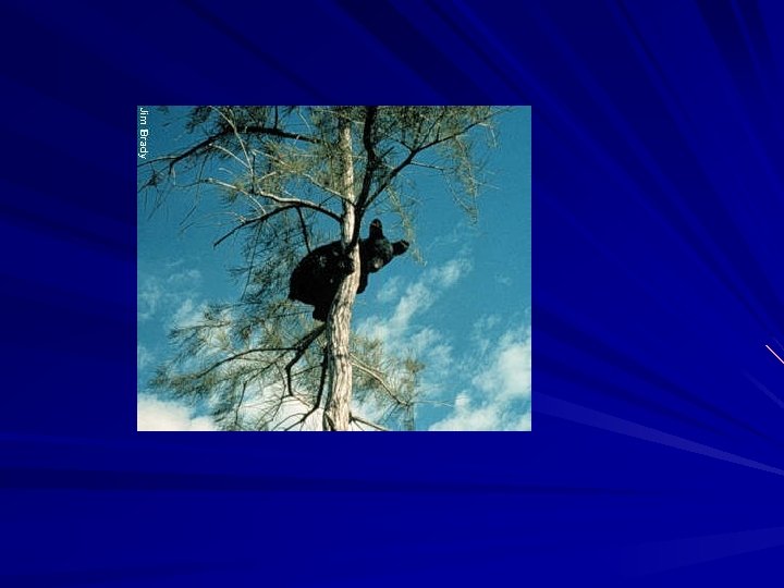
 Remaining Stable Black Bear Populations
 Potential black bear habitat within 50 km of existing conservation areas with stable black bear populations.
 Potential Black Bear Habitat in this Area
 Bear Habitat in Entonia Greenway
 USE OF THESE MAPS Project maps are intended to help guide land acquisition, land conservation, land-use planning, and regulatory programs at many levels. The maps represent our best estimate of those Florida lands that require some form of conservation to ensure that biodiversity is maintained for future generations.
 Landscape approach vs Site-specific approach
 Traditional Land Use Planning: concentrates on the characteristics of the particular site under study, with little or no consideration of surrounding features or impacts
 System wide Focus It is felt by many that the failure over the past decades to adequately protect native ecosystems and landscapes was largely due to site-specific approach to environmental review and permitting. To that end, many of today’s environmental planning and design programs emphasize and incorporate a system-wide focus to ensure that all characteristics and potential ramifications are considered.
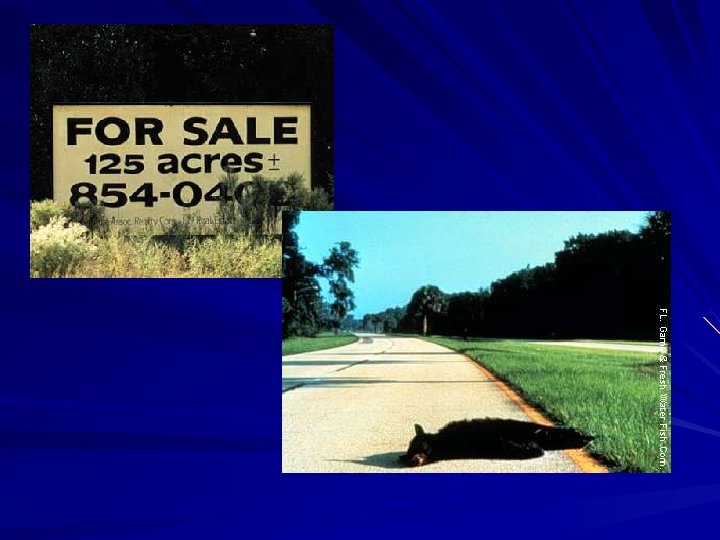
 Fragmentation is the separation of habitat in a landscape. It means chopping a wild place into pieces by putting a road , fence, house, building, powerline, etc. through it. Some species will refuse to cross even a dirt road. Some species will cross a road to their demise.
 Statewide Ecological Network
 Greenways System Planning Project developed the “Statewide Ecological Network. ”
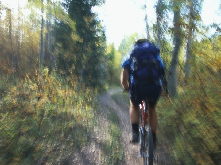
 “Connecting Florida’s Communities with Greenways and Trails. ”
 The Executive Summary recommended: “It is essential that the Ecological Network be incorporated into the planning process. . ” pp. 12 -13.
 “It is essential that the Ecological Network be incorporated into the planning process…”
 What is a Statewide Greenways System Purpose? maintenance and restoration of connectivity, of ecological systems It is also intended to create the opportunity for trail users It is further intended to protect sites and landscapes of cultural and historic significance.
 Identification of Critical Linkages Within the Florida Ecological Greenways Network A report prepared by the University of Florida, Geo. Plan Center for the Florida Department of Environmental Protection, Office of Greenways & Trails July, 2002
 For more information, contact: Dr. Tom Hoctor University of Florida, Geo. Plan Center P. O. Box 115704 Gainesville, FL 32611 -5704 Phone: 352 -392 -50374 Or Jim Wood, Assistant Director Office of Greenways & Trails Florida Department of Environmental Protection 3900 Commonwealth Blvd. , MS 795 Tallahassee, FL 32399 -3000 Phone: 850 -245 -2052 2
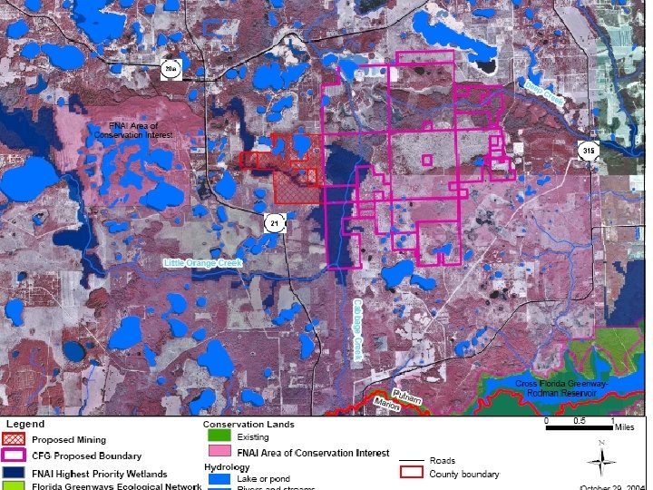
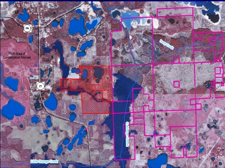
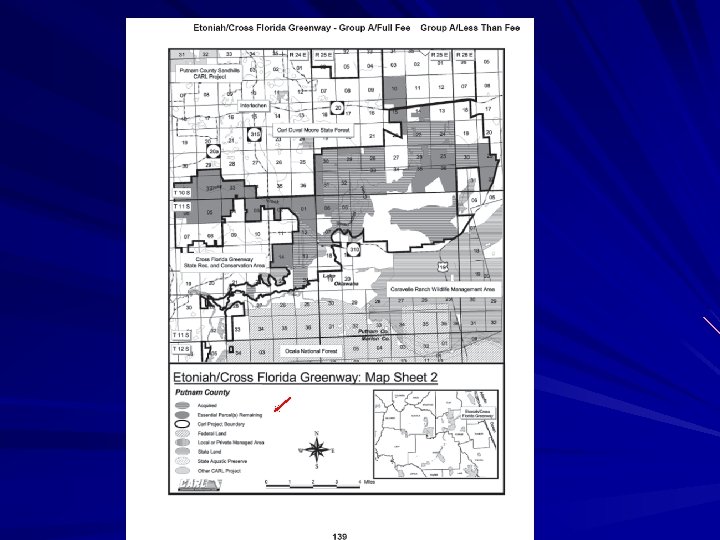
 Ocala National Forest to Camp Blanding Critical Linkage
 Gaps Study 1994 Strategic Habitat Conservation Areas Greenways System Planning Project Florida Ecological Greenways Network Critical Linkages Within the Florida Ecological Greenways
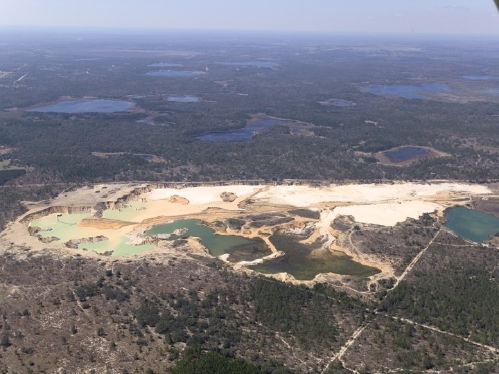
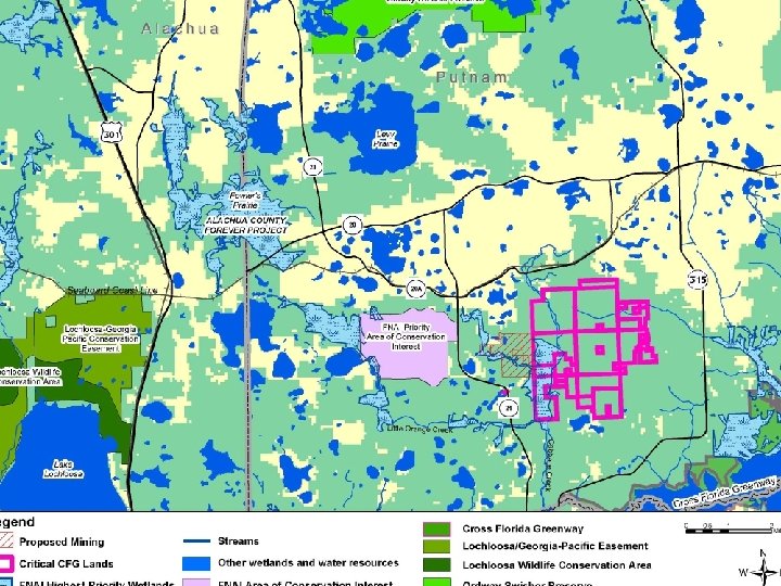
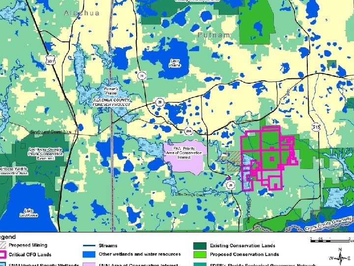
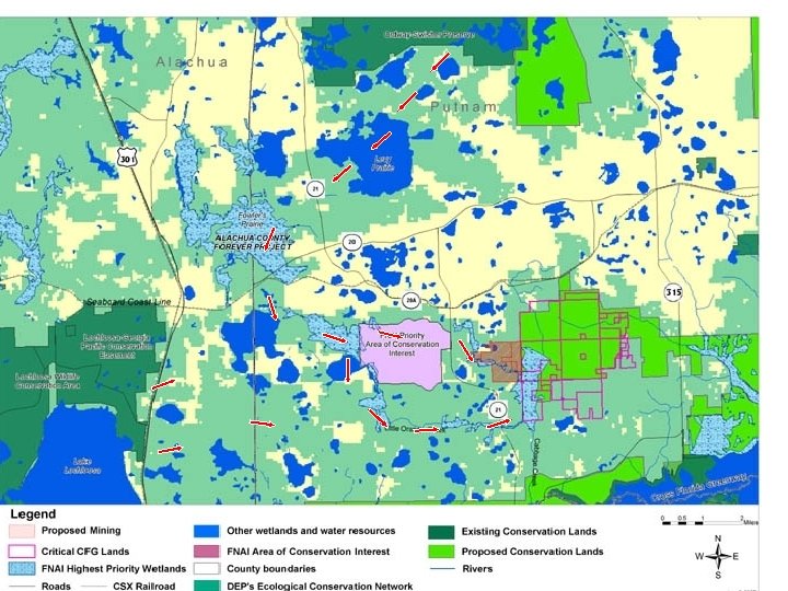
 What does this have to do with this site?
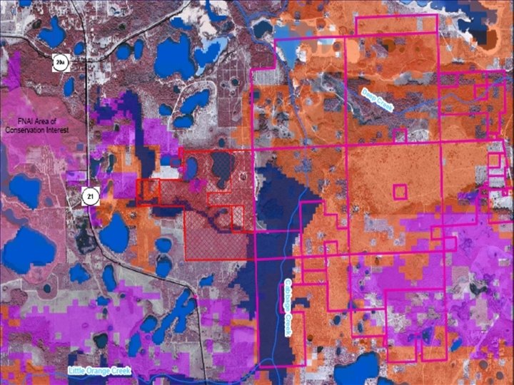
 At least 23 species of great conservation interest
 Florida Forever
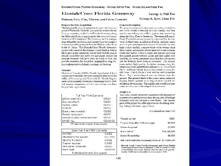
 Liberty / Gadsden / Calhoun") Group A Projects Project Name County Apalachicola River (FF/LTF) Liberty / Gadsden / Calhoun / Jackson Babcock Ranch (LTF) Charlotte / Lee Bear Creek (FF / LTF) Calhoun / Bay / Gulf Big Bend Swamp/ Holopaw Ranch (LTF) Osceola Bombing Range Ridge (FF / LTF) Polk / Osceola Brevard Coastal Scrub Ecosystem (FF/ SH) Brevard Caber Coastal Connector Tract (FF) Levy Camp Blanding - Osceola Greenway (FF/ LTF) Baker / Union / Bradford / Clay Corkscrew Regional Ecosystem Watershed (FF) Collier / Lee Coupon Bight / Key Deer (SH) Monroe Devil’s Garden (FF) Hendry / Collier Escribano Point (FF) Santa Rosa Etoniah / Cross Fla. Greenway (LTF / FF) Putnam / Marion / Clay / Levy / Citrus Fisheating Creek (LTF) Glades / Highlands Flagler County Blueway (FF) Flagler Florida Keys Ecosystem (FF) Monroe Florida Springs Coastal Greenway (FF) Citrus Florida's First Magnitude Springs (FF) Bay/ Hernando/ Jackson/ Lafayette/ Leon/ Levy/ Madison/ Marion/ Wakulla/ Suwannee/ Washington/ Walton Garcon Ecosystem (FF) Santa Rosa Green Swamp (LTF) Lake / Polk Indian River Lagoon Blueway (FF) Volusia / Brevard / Indian River / St. Lucie/ Martin Lafayette Forest (FF / LTF) Lafayette Lake Santa Fe (FF) Alachua / Bradford Lake Wales Ridge Ecosystem (FF/ LTF/ SH) Highlands / Polk / Lake / Osceola Letchworth Mounds (FF) Jefferson / Leon Nokuse Plantation (LTF) Walton / Washington North Key Largo Hammocks (SH) Monroe Northeast Florida Blueway (FF) Duval / St Johns / Flagler
Group A Projects Project Name County Apalachicola River (FF/LTF) Liberty / Gadsden / Calhoun / Jackson Babcock Ranch (LTF) Charlotte / Lee Bear Creek (FF / LTF) Calhoun / Bay / Gulf Big Bend Swamp/ Holopaw Ranch (LTF) Osceola Bombing Range Ridge (FF / LTF) Polk / Osceola Brevard Coastal Scrub Ecosystem (FF/ SH) Brevard Caber Coastal Connector Tract (FF) Levy Camp Blanding - Osceola Greenway (FF/ LTF) Baker / Union / Bradford / Clay Corkscrew Regional Ecosystem Watershed (FF) Collier / Lee Coupon Bight / Key Deer (SH) Monroe Devil’s Garden (FF) Hendry / Collier Escribano Point (FF) Santa Rosa Etoniah / Cross Fla. Greenway (LTF / FF) Putnam / Marion / Clay / Levy / Citrus Fisheating Creek (LTF) Glades / Highlands Flagler County Blueway (FF) Flagler Florida Keys Ecosystem (FF) Monroe Florida Springs Coastal Greenway (FF) Citrus Florida's First Magnitude Springs (FF) Bay/ Hernando/ Jackson/ Lafayette/ Leon/ Levy/ Madison/ Marion/ Wakulla/ Suwannee/ Washington/ Walton Garcon Ecosystem (FF) Santa Rosa Green Swamp (LTF) Lake / Polk Indian River Lagoon Blueway (FF) Volusia / Brevard / Indian River / St. Lucie/ Martin Lafayette Forest (FF / LTF) Lafayette Lake Santa Fe (FF) Alachua / Bradford Lake Wales Ridge Ecosystem (FF/ LTF/ SH) Highlands / Polk / Lake / Osceola Letchworth Mounds (FF) Jefferson / Leon Nokuse Plantation (LTF) Walton / Washington North Key Largo Hammocks (SH) Monroe Northeast Florida Blueway (FF) Duval / St Johns / Flagler
 Okeechobee Osceola Pine Savannas (FF) Osceola Panther Glades (FF/ LTF) Hendry") Okeechobee Battlefield (FF) Okeechobee Osceola Pine Savannas (FF) Osceola Panther Glades (FF/ LTF) Hendry Perdido Pitcher Plant Prairie (FF) Escambia Pine Island Slough (FF) Osceola / Indian River Promise Ranch (LTF) Lake Spruce Creek (SH) Volusia St. Joe Timberland (FF) Gadsden / Gulf / Franklin / Leon / Wakulla / Liberty / Walton/ Bay / Jefferson / Taylor / Washington Terra Ceia (FF) Manatee Tiger Island / Little Tiger Island (FF) Nassau Upper St. Marks River Corridor (FF) Leon / Jefferson / Wakulla Volusia Conservation Corridor (FF / LTF) Volusia Wacissa / Aucilla River Sinks (FF) Jefferson / Taylor Wakulla Springs Protection Zone (FF) Wakulla Wekiva-Ocala Greenway (FF) Lake / Orange / Volusia / Seminole Yellow River Ravines Santa Rosa / Okaloosa
Okeechobee Battlefield (FF) Okeechobee Osceola Pine Savannas (FF) Osceola Panther Glades (FF/ LTF) Hendry Perdido Pitcher Plant Prairie (FF) Escambia Pine Island Slough (FF) Osceola / Indian River Promise Ranch (LTF) Lake Spruce Creek (SH) Volusia St. Joe Timberland (FF) Gadsden / Gulf / Franklin / Leon / Wakulla / Liberty / Walton/ Bay / Jefferson / Taylor / Washington Terra Ceia (FF) Manatee Tiger Island / Little Tiger Island (FF) Nassau Upper St. Marks River Corridor (FF) Leon / Jefferson / Wakulla Volusia Conservation Corridor (FF / LTF) Volusia Wacissa / Aucilla River Sinks (FF) Jefferson / Taylor Wakulla Springs Protection Zone (FF) Wakulla Wekiva-Ocala Greenway (FF) Lake / Orange / Volusia / Seminole Yellow River Ravines Santa Rosa / Okaloosa
 Why is this important? ?
 The Economy!!!!!
 “Long-range activities proposed include a multipurpose trail and facilities for public access. ” (Etoniah Creek/CFG Florida Forever Project description)
 stated:") Economic Impacts of Protecting Rivers, Trails and Greenway Corridors (1990) stated: "proximity to greenways, rivers, and trails can increase sales price, increase the marketability of adjacent properties, and promote faster sales. " This study also reported that visitors from outside of Leon and Wakulla counties to the Tallahassee-St. Marks Historic Railroad State Trail spent $400, 000 annually in trail-use related expenses
Economic Impacts of Protecting Rivers, Trails and Greenway Corridors (1990) stated: "proximity to greenways, rivers, and trails can increase sales price, increase the marketability of adjacent properties, and promote faster sales. " This study also reported that visitors from outside of Leon and Wakulla counties to the Tallahassee-St. Marks Historic Railroad State Trail spent $400, 000 annually in trail-use related expenses
 The") A Study of the Users and Property Owners from Three Trails (1992 ) The Tallahassee-St. Marks Historic Railroad State Trail has resulted in a total annual economic impact of over $1. 8 million on this rural, 16 mile-long trail.
A Study of the Users and Property Owners from Three Trails (1992 ) The Tallahassee-St. Marks Historic Railroad State Trail has resulted in a total annual economic impact of over $1. 8 million on this rural, 16 mile-long trail.
 In 1993, approximately 170, 000 persons used this trail, and the City of Tallahassee is currently extending it five-miles north to the Florida State University campus.
. value of") The Effects of Greenbelts on Residential Property Values, Land Economics, May 1978). value of property adjacent to the greenbelt is 32 percent greater aggregate property value was approximately $5. 4 million greater tax revenue alone could recover the initial cost of the $1. 5 million greenbelt in three years
The Effects of Greenbelts on Residential Property Values, Land Economics, May 1978). value of property adjacent to the greenbelt is 32 percent greater aggregate property value was approximately $5. 4 million greater tax revenue alone could recover the initial cost of the $1. 5 million greenbelt in three years
 Other studies Users of the Elroy-Sparta Trail in Wisconsin spend an average of 25. 14 person per day The average daily person expenditure of users of the Sugar River Trail in Wisconsin increased from $5. 20 in 1979 to $10. 99 in 1984 Surveys of users of Minnesota's Sugar Valley Trail spent between $6. 11 and $13. 92 person per day Users of the Heartland State Trail in Minnesota were estimated to spend $7. 49 a day on the trail with an annual total of $375, 800 in direct spending by trail users $6. 2 million in sales from Katy-Missouri River Trail tourism generated $960, 000 in sales tax revenue in 1987
 The Joint Economic Committee of the U. S. Congress reports that a city's quality of life is more important than purely business -related factors when comes to attracting new businesses, particularly in the hightech and service industries (Sign Control News "Fact Sheet: Sign Control and Economic Development, " November/December 1987).
 The National Association of Home Builders reported the value of residential property is 10 to 20 percent higher in the vicinity of park facilities (Source: Florida Planning, April 1995).
 Why would Putnam County risk losing funding for the state to buy conservation lands that could bring increased property values and income into the county from trail users?
 OCKLAWAHA RALLY IMPLAN RESULTS Direct OUTPUT TOTAL VALUE ADDED EMPLOYMENT RESULTS Indirect Induced Total $177, 595 $48, 632 $62, 312 $288, 539 120, 578 29, 288 40, 290 $190, 156 3. 8 1 1. 3 6. 2
 FINAL Output total $288, 539 - FINAL Value Added $190, 156 and Employment results 6. 2 job years (jobs per year for a year duration only). These results are for statewide impacts --though likely most of the impacts are quite local. Tim Lynch, Ph D Director Center for Economic Forecasting and Analysis Florida State University
 Policy E. 1. 3. 6. B In the process of reviewing site plans, the County shall assess the compatibility of land use development on parcels adjacent to the Ocala NF, WMA, State or Private Preserves or other State or Federal natural resource areas. Policy E. 1. 4. 2 The County shall request technical assistance from State agencies to study the feasibility of designating viable wildlife corridors in the County…. Policy E. 1. 4. 4 In coordination with public and private conservation entities the County shall identify, enhance, and promote a greenway that includes lands that are environmentally valuable or provide recreational opportunities in Putnam County.
 In Summary This mine sits in the “Grand Central Station” of wildlife corridors It is an area of great conservation interest and high biodiversity The county commission must make its decision using a broad-based view, not just focusing on the property itself It’s decision could have long-range implications for the future of the local Greenway This CPA is against your comprehensive plan
 The Future